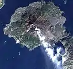
Sakurajima is an active volcano and a former island (now connected to the mainland) of the same name in Kagoshima Prefecture in Kyūshū, Japan. It is a stratovolcano with the summit split into three peaks, Kitadake (northern peak), Nakadake (central peak) and Minamidake (southern peak) which is active now. The surface of the island is about 77 km². Its North Peak is Sakurajima's highest peak, rising to 1,117 metres above sea level. The mountain is located in a part of Kagoshima Bay known as Kinkō Bay. The former island is part of the city of Kagoshima. In 1914, a great eruption occurred, burying the straits with lava, thus connecting the former island to the Osumi Peninsula, so that Sakurajima is no longer an island. The volcanic activity still continues, dropping large amounts of volcanic ash on the surroundings. Earlier eruptions built the white sands highlands in the region. Sakurajima is located in the Aira caldera, formed in an enormous eruption 22,000 years ago. Several hundred cubic kilometres of ash and pumice were ejected, causing the magma chamber underneath the erupting vents to collapse. The resulting caldera is over 20 kilometers across. Tephra fell as far as 1000 km from the volcano. Sakurajima was formed by later activity within the caldera, beginning about 13,000 years ago. It lies about 8 kilometers south of the centre of the caldera. Its first eruption in recorded history occurred in 963 AD. Most of its eruptions are strombolian, affecting only the summit areas, but larger plinian eruptions have occurred in 1471-1476, 1779-1782 and 1914. (Full article...)