Selected article 1
Portal:Roads/Selected article/1
The main alternative route is the Princes Highway which goes via the coast rather than inland.
Selected article 2
Portal:Roads/Selected article/2
Selected article 3
Portal:Roads/Selected article/3

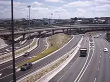
The road is mostly a federally funded national highway due to its national strategic importance. It is signed as National Highway 94 except for a 9 km stretch between the Great Eastern Highway Bypass and Roe Highway, and the 40 km section between Coolgardie and Kalgoorlie. It is also signed as Highway 1 between The Causeway and Morrison Road, and State Route 51 between Johnson Street, Guildford, and Roe Highway.
Selected article 4
Portal:Roads/Selected article/4

The organisation responsible for the charge is Transport for London (TfL); Capita Group operates the scheme under contract. The system is run on a generally automatic basis using CCTV and Automatic Number Plate Recognition.
Selected article 5
Portal:Roads/Selected article/5
Throughout much of Canada, there are at least two routes designated as part of the Trans-Canada Highway. For example, in the western provinces, both the main Trans-Canada route and the Yellowhead Highway are part of the Trans-Canada system.
Selected article 6
Portal:Roads/Selected article/6
In English-speaking countries the term is used in the United Kingdom (a motorway is also called a traffordd (plural: traffyrdd) in Welsh), parts of Australia, New Zealand, Pakistan, some other Commonwealth nations, and Ireland (a motorway is also called a mótarbhealach (plural: mótarbhealaí) in Irish). In Ireland, a road built to motorway standard, but without the designation (and the regulations and traffic restrictions resulting from that designation), is known as a High-quality dual carriageway.
Selected article 7
Portal:Roads/Selected article/7
The central motorway junction forms the intersection between the three major motorways of Auckland (Auckland Northern Motorway (1), Auckland Southern Motorway (1), and Northwest Motorway (16)), and provides access from these routes to the city centre. It is principally located in a series of gullies to the south and east of the CBD and in cuttings to the west.
Selected article 8
Portal:Roads/Selected article/8

The current route of the London section of the A1 road was (for the most part) designated as such in 1927. It comprises a number of historic streets in central London and the former suburbs of Islington, Holloway and Highgate and long stretches of purpose-built new roads in the outer London borough of Barnet, built to divert traffic away from the congested suburbs of Finchley and High Barnet.
Selected article 9
Portal:Roads/Selected article/9

It was built to provide links between Stoke-on-Trent and the M6, before being extended to Nantwich. Construction has taken place over several stages, beginning in 1962, with the final section of the original route being completed similar to the original plans in 2006. As a trunk road it is maintained by the Highways Agency.
Selected article 10
Portal:Roads/Selected article/10

The first section of the PDR to be completed was the Southern Way Link Road between Newport Road (A4161 road) and the Eastern Avenue (A48 road) in 1978.rem When fully completed, the road will form part of the Cardiff ring-road system. The PDR runs west, south and east of Cardiff, with the M4 between junction 30 and junction 33 completing the northern section. The PDR is dual carriageway for its entire length except for the East Moors Viaduct, which is a single carriageway.
Selected article 11
Portal:Roads/Selected article/11
 ]
]
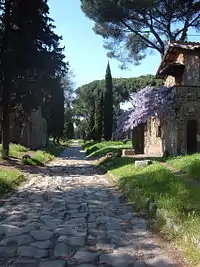
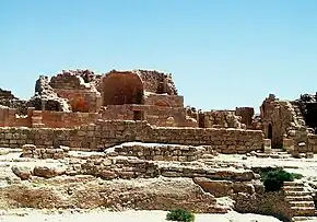
- Appia teritur regina longarum viarum
- "the Appian way is commonly said to be the queen of the long roads"
The road is named after Appius Claudius Caecus, the Roman censor who began and completed the first section as a military road to the south in 312 BC during the Samnite Wars.
Selected article 12
Portal:Roads/Selected article/12
Selected article 13
Portal:Roads/Selected article/13
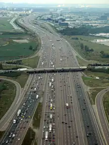
On August 24, 2007, the stretch of highway between Toronto (from Highway 404/Don Valley Parkway) and Trenton (from Glen Miller Road) was given the additional name Highway of Heroes, in honour of Canadian Forces personnel killed during the War in Afghanistan. Along the route are several heritage sites, an international bird watching area, saline lakes, as well as regional and provincial parks. Museums and historical markers commemorate the region's history along the highway.
Selected article 14
Portal:Roads/Selected article/14 The Millau Viaduct (French: le Viaduc de Millau) is a large cable-stayed road-bridge that spans the valley of the River Tarn near Millau in southern France. Designed by the structural engineer Michel Virlogeux and British architect Norman Foster, it is the tallest vehicular bridge in the world, with one mast's summit at 343 metres (1,125 ft) — slightly taller than the Eiffel Tower and only 38 m (125 ft) shorter than the Empire State Building. The viaduct is part of the A75-A71 autoroute axis from Paris to Béziers. It was formally dedicated on 14 December 2004, inaugurated the day after and opened to traffic two days later. The bridge won the 2006 IABSE Outstanding Structure Award.
The bridge’s construction broke three world records:
- The highest pylons in the world: pylons P2 and P3, 244.96 metres (803 ft 8 in) and 221.05 metres (725 ft 3 in) in height respectively.
- The highest mast in the world: the mast atop pylon P2 peaks at 343 metres (1,125 ft).
- The highest road bridge deck in the world, 270 m (890 ft) above the Tarn River at its highest point.
Selected article 15
Portal:Roads/Selected article/15

The M54 spur connects the M6 motorway near Essington, Staffordshire with the A5 trunk road at Wellington, Shropshire. The motorway forms part of the strategic route to North Wales, roughly following the path of the Roman Watling Street and the A5 north-westwards, towards the port of Holyhead. It is the only motorway in Shropshire, and forms a vital part of the county's road network.
Selected article 16
Portal:Roads/Selected article/16

The motorway, which was first proposed in the 1930s, and originally conceived as two separate routes, was built in stages between 1971 and 1976, with construction beginning at Pole Moor and finishing in Tarbock. The motorway also absorbed the northern end of the Stretford-Eccles bypass, which was built between 1957 and 1960. Adjusted for inflation to 2007, the motorway cost approximately £765 million to build. The motorway is relatively busy, with an average daily traffic flow of 100,000 cars in Yorkshire, and has several areas prone to gridlock, in particular, between Leeds and Huddersfield in West Yorkshire.
Selected article 17
Portal:Roads/Selected article/17
Selected article 18
Portal:Roads/Selected article/18
The road is a very busy commuter route, as it is the only dual carriageway passing through the south eastern suburbs of Dublin, as well as close to the many commuter towns along the east coast as far south as Gorey. Summer Friday and Sunday evenings also see very heavy traffic as Dubliners decamp to, and return from, their many holiday home locations along the Co. Wicklow and Co. Wexford coastlines.
Selected article 19
Portal:Roads/Selected article/19
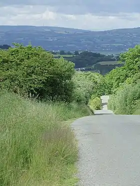
The first routes in Ireland were prehistoric trackways, some of which were later developed into roads suited for wheeled vehicles. Many of Ireland's minor roads "may well have had their origin in pre-existing paths and trackways aligned in direct response to the physical environment". Traces of these "evolved roads" which developed over very long periods, frequently from tracks of the prehistoric period, are still evident. Such roads usually followed the tops of ridges and crossed rivers and streams at fording points.
Selected article 20
Portal:Roads/Selected article/20

In most countries, it usually refers to the German autobahn specifically. The recommended speed of the German autobahn is 130 km/h (81 mph), but there is no general speed limit. Austrian and Swiss autobahns have general speed limits of 130 km/h (81 mph) and 120 km/h (75 mph), respectively. In German, the word is pronounced as described above, and its plural is Autobahnen; in English, however, the segment "auto" is typically pronounced as in other English words such as "automobile". The official name of the autobahn in Germany is Bundesautobahn (BAB) (Federal Freeway). Autobahns are built and maintained by the federal government (as are the federal highways), thus the name "Federal Freeway". The first were built in the 1920s, and in the 1930s the official name was "Reichsautobahn" (Freeways of the Reich).
Selected article 21
Portal:Roads/Selected article/21
Selected article 22
Portal:Roads/Selected article/22

Selected article 23
Portal:Roads/Selected article/23 Portal:Roads/Selected article/23
Selected article 24
Portal:Roads/Selected article/24 Portal:Roads/Selected article/24
Selected article 25
Portal:Roads/Selected article/25 Portal:Roads/Selected article/25
Usage
The layout design for these subpages is at Portal:Roads/Selected article/Layout.
- Add a new selected article to the next available subpage.
- Update "max=" to new total for its {{Random portal component}} on the main page.
- Please also feel free to add to the following portals as well: U.S. Roads - London transport and Transport
Feel free to directly add featured, A or GA class Roads content articles to the above list which are now rotated automatically through the portal.