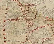
The Shire of Ravenswood was a local government area located in North Queensland, Australia. Its administrative centre was in Ravenswood.
History
Ravenswood Division was created on 11 November 1879 as one of 74 divisions around Queensland under the Divisional Boards Act 1879 with a population of 1412.[1]
On 18 January 1882, the subdivisions were abolished (meaning all of board members would be elected by all residents rather than having representatives from different parts of the division).[2]
With the passage of the Local Authorities Act 1902, the Ravenswood Division became the Shire of Ravenswood on 31 March 1903.
However, with the decline in Ravenwood's population after World War I, it became increasingly financially unviable to have a separate local government authority.[3] On 1 January 1930, the Shire of Ravenswood was abolished and absorbed into the Shire of Dalrymple as its No. 3 division.[4][5][6]
On 15 March 2008, under the Local Government (Reform Implementation) Act 2007 passed by the Parliament of Queensland on 10 August 2007, the Shire of Dalrymple was amalgamated with the separate City of Charters Towers to form the Charters Towers Region.[7]
Chairmen
- 1927: Joseph Podosky [8]
References
- ↑ "Proclamation [Ravenswood Division]". Queensland Government Gazette. 11 November 1879. p. 25:1006.
- ↑ "Proclamation [Ravenswood Division subdivisions]". Queensland Government Gazette. 21 January 1882. p. 30:161.
- ↑ "Local Authorities". The Northern Miner. Charters Towers, Qld.: National Library of Australia. 30 April 1924. p. 2. Retrieved 28 December 2013.
- ↑ "Order in Council". Queensland Government Gazette. 21 December 1929. p. 133:2125. Abolished Shire of Ravenswood and merged it with Dalrymple, among other changes
- ↑ "Dalrymple Shire". Townsville Bulletin. Qld.: National Library of Australia. 19 May 1930. p. 6. Retrieved 28 December 2013.
- ↑ "Dalrymple Shire Council Monthly Meeting". The Northern Miner. Charters Towers, Qld.: National Library of Australia. 12 February 1930. p. 4. Retrieved 28 December 2013.
- ↑ "Agency ID 11043, Charters Towers Regional Council". Queensland State Archives. Retrieved 24 September 2013.
- ↑ Pugh, Theophilus Parsons (1927). Pugh's Almanac for 1927. Retrieved 13 June 2014.