Rawla Mandi Tehsil
रावला मंडी तहसील | |
|---|---|
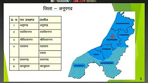
 A map of Anupgarh district with Rawla Mandi Tehsil highlighted | |
| Country | India |
| State | Rajasthan |
| District | Anupgarh |
| Headquarters | Rawla Mandi |
Rawla Mandi Tehsil (Hindi: and Rajasthani रावला मंडी तहसील, Punjabi: ਰਾਵਲਾ ਮੰਡੀ ਤਹਿਸੀਲ) is one of the 5 tehsils from the Anupgarh district in Rajasthan, India. It was carved out of Gharsana tehsil and given the status of tehsil by CM Vasundhara Raje in 2017.[1][2] Its northern border connects it with Gharsana tehsil of Anupgarh district and Chhatargarh and Khajuwala tehsil of Bikaner district are in the south. Its western border is connected with Fort Abbas Tehsil that is the Bahawalnagar district of Pakistani Punjab.
- Major villages are Rawla Mandi (8PSD-b), Rawla Gaon(10Kd)
References
- ↑ "रावला को तहसील का दर्जा, सीएम ने की घोषणा- m.bhaskar.com".
- ↑ Inauguration of the building of Rawla Mandi tehsil in Rawla Mandi town https://m.bhaskar.com/news/RAJ-OTH-MAT-latest-rawala-mandi-news-061514-2553971-NOR.html?ref=ht
External links
This article is issued from Wikipedia. The text is licensed under Creative Commons - Attribution - Sharealike. Additional terms may apply for the media files.