| Nive | |
|---|---|
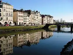 Nive in Bayonne | |
.png.webp) | |
| Location | |
| Country | France |
| Physical characteristics | |
| Source | |
| • location | Pyrenees |
| • coordinates | 43°03′38″N 1°11′49″W / 43.06056°N 1.19694°W |
| Mouth | |
• location | Adour |
• coordinates | 43°29′38″N 1°28′27″W / 43.49389°N 1.47417°W |
| Length | 79 km (49 mi) |
| Basin size | 1,030 km2 (400 sq mi) |
| Basin features | |
| Progression | Adour→ Atlantic Ocean |
The Nive (French pronunciation: [niv]; Basque: Errobi; Occitan: Niva) is a French river that flows through the French Basque Country. It is a left tributary of the river Adour. It is 78.9 km (49.0 mi) long.[1] The river's source in the Pyrenees in Lower Navarre. The river Nive was made famous by the Le petit Nicolas series.
Geography
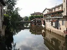
Nive in Saint-Jean-Pied-de-Port
_-_Fonds_Ancely_-_B315556101_A_MALBOS_2_013.jpg.webp)
Nive in Saint-Jean-Pied-de-Port in 1843, by Eugène de Malbos

The Nive proper is formed from three head rivers in Saint-Jean-Pied-de-Port:
- The Nive de Béhérobie (main stream)
- The Laurhibar
- The Nive d'Arnéguy.
The Nive passes through the towns of Estérençuby (Nive de Béhérobie), Saint-Jean-Pied-de-Port, Bidarray, Cambo-les-Bains, Ustaritz, Villefranque and Bayonne, where it flows into the Adour.
Principal tributaries
- Ezterrengibel or Esterenguibel
- Nive des Aldudes, from Saint-Étienne-de-Baïgorry
- Laka, from Ossès
- Baztan, from Bidarray
- Latsa, from Espelette
See also
References
External links
Wikimedia Commons has media related to Nive.
- (in French) Au fil des Nives
- (in French) Tour de la Haute vallée de la Nive
- (in French) Contrat de Rivière des Nives
This article is issued from Wikipedia. The text is licensed under Creative Commons - Attribution - Sharealike. Additional terms may apply for the media files.