| Ohre | |
|---|---|
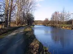
 The Ohre near Calvörde | |
| Location | |
| Country | Germany |
| States | |
| Physical characteristics | |
| Source | |
| • location | Lower Saxony |
| Mouth | |
• location | Elbe |
• coordinates | 52°18′40″N 11°45′55″E / 52.31111°N 11.76528°E |
| Length | 104.9 km (65.2 mi) [1] |
| Basin size | 1,670 km2 (640 sq mi) [1] |
| Basin features | |
| Progression | Elbe→ North Sea |
The Ohre is a river in northern Germany, left tributary to the Elbe. Its total length is 103 kilometres (64 mi). Its source is north of Wolfsburg, in Lower Saxony. It flows generally south-east, at first following the border of Lower Saxony and Saxony-Anhalt. After Buchhorst it flows completely through Saxony-Anhalt, along the Mittellandkanal. It flows into the Elbe in Rogätz, north of Magdeburg. The towns Brome, Calvörde, Haldensleben and Wolmirstedt lie along the river. The upper course of the Ohre is in the Drömling nature reserve.
Between the end of the Second World War and German reunification, the Ohre separated East from West Germany and so formed part of the Inner German border.
See also
References
This article is issued from Wikipedia. The text is licensed under Creative Commons - Attribution - Sharealike. Additional terms may apply for the media files.