| Rivey Hill | |
|---|---|
| Highest point | |
| Elevation | 367 ft (112 m) |
| Prominence | 69 ft (21 m) |
| Listing | (none) |
| Geography | |
| Location | Cambridgeshire, England |
| OS grid | TL567480 |
| Topo map | OS Landranger 154 |
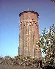
Rivey Hill is a hill overlooking Linton in Cambridgeshire, England (grid reference TL567480). At 367 feet (112 m) it is the highest point for several miles around. The hill has a steep slope leading down to Linton and a prominence of 69 feet (21 m). The highest point is on private land but a bridleway from Linton crosses near the top. A watertower on the hill identifies it when seen from a distance.
The ascent of the hill is the start of a circular walk, detailed in Jarrold's Walks in Cambridgeshire, which goes north from the top to a Roman Road, follows this over the 312 feet (95 m) Hildersham Hill for 2 miles (3.2 km), then descends to Hildersham and returns along the valley of the River Granta to Linton.
See also
52°06′29″N 0°17′12″E / 52.10813°N 0.28676°E