St. Albans | |
|---|---|
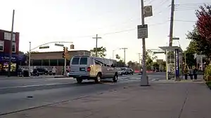 Merrick Boulevard in St. Albans | |
Location within New York City | |
| Coordinates: 40°41′24″N 73°45′54″W / 40.69°N 73.765°W | |
| Country | |
| State | |
| City | |
| County/Borough | |
| Community District | Queens 12[1] |
| Named for | St Albans, Hertfordshire, England |
| Population (2010)[2] | |
| • Total | 48,593 |
| Ethnicity | |
| • Black | 88.6% |
| • Hispanic | 6.5 |
| • Two or more | 2.2 |
| • White | 1.0 |
| • Other | 1.7 |
| Economics | |
| Time zone | UTC−5 (EST) |
| • Summer (DST) | UTC−4 (EDT) |
| ZIP Code | 11412 |
| Area codes | 718, 347, 929, and 917 |
St. Albans is a residential neighborhood in the southeastern portion of the New York City borough of Queens. It is bordered by Jamaica to the northwest, Hollis to the north, Queens Village to the northeast, Cambria Heights to the east, Laurelton to the southeast, Springfield Gardens to the south, and South Jamaica to the southwest.[4] St. Albans is centered on the intersection of Linden Boulevard and Farmers Boulevard, about two miles north of John F. Kennedy International Airport.
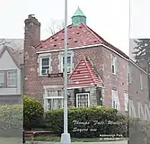
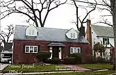
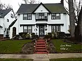
The small western enclave of Addisleigh Park is a U.S. historic district where many notable African Americans have lived, including Jackie Robinson, W. E. B. Du Bois, Lena Horne, and many jazz musicians such as Fats Waller, Ella Fitzgerald and Count Basie.[5]
St. Albans is located in Queens Community District 12 and its ZIP Code is 11412.[1] It is patrolled by the New York City Police Department's 113th Precinct.[6] Politically, St. Albans is represented by the New York City Council's 27th and 28th Districts.[7]
History
Early settlement
Part of a land grant to Dutch settlers from New Netherland Governor Peter Stuyvesant in 1655, the area, like much of Queens, remained farmland and forest for most of the next two centuries.
By the 1800s, the lands of four families—the Remsens, Everitts, Ludlums, and Hendricksons—formed the nucleus of this sprawling farm community in the eastern portion of the Town of Jamaica. In 1814, when the Village of Jamaica (the first village on Long Island) was incorporated, its (the village's) boundaries extended eastward to Freeman's Path (now Farmers Boulevard), and south to Lazy Lane (called Central Avenue in 1900, then Foch Boulevard in the 1920s,[lower-alpha 1][10][9][11] thus including parts of present-day St. Albans.[12] In 1852, the old mill pond that is now at the center of Baisley Pond Park was acquired by the Brooklyn waterworks for use as a reservoir.[13]
Later development
In 1872, the Long Island Rail Road's Cedarhurst Cut-off was built through the area, but no stop appears on the first timetables. In 1892, an area called Francis Farm was surveyed and developed for housing. There were numerous Francis families farming in the eastern portion of the Town of Jamaica in the 1880s.[14] Francis Lewis Boulevard (named for a signer of the Declaration of Independence, from Queens), which does not yet appear on maps from 1909,[15] nor in 1910,[16] is now the eastern boundary of St. Albans.
Soon, the first street lights illuminated the crossroads that is now Linden Boulevard and Farmers Boulevard. New shops clustered around August Everitt's lone store. By July 1, 1898, the St. Albans Long Island Rail Road station opened where the tracks crossed Locust Avenue (now Baisley Boulevard).[17][18] The station was razed and replaced with the current, grade separated station on October 15, 1935.
In 1899, a year after Queens became part of New York City (and with the Town of Jamaica and the Village of Jamaica thereby dissolved), the new post office for the 600 residents[19] was named St. Albans, after St Albans in Hertfordshire, England, which itself was named after a Saint Alban, thought to be the first Christian martyred in England. The name had been in use for the area since at least 1894 for the name of the school district,[20] and the LIRR station was named St. Albans when it opened in 1898. A 1909 map also shows a St Albans Avenue and a St Albans Place in the area.[15][21]
The site was originally occupied by the St. Albans Golf Course and Country Club,[22][23] which was completed in 1915.[24] The club brought rich and famous golfers, including baseball star Babe Ruth,[25] and hosted the 1930 Metropolitan Amateur.[26] The Depression forced the golf course owners to try to sell, but plans for private development fell through. The land was seized by the federal government in 1942,[22] and construction soon began on the St. Albans Naval Hospital,[27] which opened in 1943.[28][29] After construction was completed in 1950, the hospital had 3000 beds and contained a network of 76 wards.[25] The hospital was turned over to the Veterans Administration in 1974,[30] reopening as a VA hospital two years later,[31] and more recently evolved into the Veterans Administration St. Albans Primary and Extended Care Facility.[23] A portion of the hospital site became Roy Wilkins Park in the 1980s.[32]
Addisleigh Park subsection
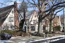
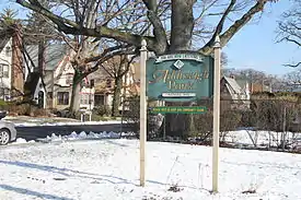
Within St. Albans is the small western enclave of Addisleigh Park, a U.S. historic district that consists of single-family homes built in a variety of styles between the 1910s and 1930s. Though originally intended as a segregated community for white people only, from the late 1930s many notable African Americans have lived there.[5] Today, it remains a predominantly African American & Jamaican enclave that is more upscale than surrounding areas in southeast Queens.[33]
Between 1900 and 1940, the village of Addisleigh Park was developed by a handful of eminent white entrepreneurs including Edwin H. Brown, Gerald C. English, and Alexander Rodman.[34] Restrictive covenants were established to prohibit the sale of any of its properties to blacks.[35] A 1926 New York Times article insists, "Addisleigh, together with the St. Albans Golf Club, was laid out under the personal direction of Edwin H. Brown, and carries a land and house restriction of the highest type."[36] Two lawsuits were filed successfully by white residents who accused their neighbors of breaking the contractual segregation imposed on the neighborhood by its developers. Simeon Bankoff, Executive Director of the New York Historic Districts Council, says about this backlash, "It was unpleasant, as it was a case of a number of narrow-minded neighbors trying to fight what they saw as an invasion of unwanted people in their area."[37] Affluent white New York City-based public figures moved into Addisleigh Park to experience the privacy of suburban seclusion. Addisleigh Park boasted well-kept rows of Tudor and Colonial homes. The neighborhood's close proximity to Manhattan allowed for quick and frequent commuting. During the Swing Era, Manhattan's 52nd Street served as the epicenter of Swing Era live entertainment and musical innovation. For this reason, many successful African American jazz musicians began to recognize Addisleigh Park as the newest suburban haven for wealthy, influential artists.
In 1948, the United States Supreme Court ruled that racially restrictive covenants violated the equal-protection clause of the 14th Amendment, though by that year, Addisleigh Park had already become a haven for world-famous African Americans in jazz and sports.[38] The neighborhood was declared a historic district by the NYC Landmarks Preservation Commission in 2011.[5]
Demographics
Based on data from the 2010 United States Census, the population of St. Albans was 48,593, a change of -1,453 (-3%) from the 50,046 counted in 2000. Covering an area of 1,778.68 acres (719.81 ha), the neighborhood had a population density of 27.3 inhabitants per acre (17,500/sq mi; 6,700/km2).[2]
The racial makeup of the neighborhood was 1% (469) White, 88.6% (43,073) African American, 0.3% (129) Native American, 0.9% (417) Asian, 0% (16) Pacific Islander, 0.5% (258) from other races, and 2.2% (1,085) from two or more races. Hispanic or Latino of any race were 6.5% (3,146) of the population.[3]
The entirety of Community Board 12, which mainly comprises Jamaica but also includes St. Albans and Hollis, had 232,911 inhabitants as of NYC Health's 2018 Community Health Profile, with an average life expectancy of 80.5 years.[39]: 2, 20 This is slightly lower than the median life expectancy of 81.2 for all New York City neighborhoods.[40]: 53 (PDF p. 84) [41] Most inhabitants are youth and middle-aged adults: 22% are between the ages of between 0–17, 27% between 25–44, and 27% between 45–64. The ratio of college-aged and elderly residents was lower, at 10% and 14% respectively.[39]: 2
As of 2017, the median household income in Community Board 12 was $61,670.[42] In 2018, an estimated 20% of St. Albans and Jamaica residents lived in poverty, compared to 19% in all of Queens and 20% in all of New York City. One in eight residents (12%) were unemployed, compared to 8% in Queens and 9% in New York City. Rent burden, or the percentage of residents who have difficulty paying their rent, is 56% in St. Albans and Jamaica, higher than the boroughwide and citywide rates of 53% and 51% respectively. Based on this calculation, as of 2018, St. Albans and Jamaica are considered to be high-income relative to the rest of the city and not gentrifying.[39]: 7
Housing
St. Albans housing consists mostly of detached, one and two-family homes. Linden Boulevard is the major shopping street. In 2011 The New York Times reported that many foreclosures were occurring and there was a high level of unemployment. At that time, many black people were moving from St. Albans to the Southern United States.[43]
Police and crime
South Jamaica and St. Albans are patrolled by the NYPD's 113th Precinct, located at 167-02 Baisley Boulevard.[6] The 113th Precinct ranked 55th safest out of 69 patrol areas for per-capita crime in 2010.[44][45] The 113th Precinct also has a lower crime rate than in the 1990s, with crimes across all categories having decreased by 86.1% between 1990 and 2018. The precinct reported 5 murders, 28 rapes, 156 robberies, 383 felony assaults, 153 burglaries, 414 grand larcenies, and 138 grand larcenies auto in 2018.[46]
Fire safety
_02_-_FDNY_Engine_275_Ladder_133.jpg.webp)
St. Albans is served by two New York City Fire Department (FDNY) fire stations:[47]
Health
As of 2018, preterm births and births to teenage mothers are more common in St. Albans and Jamaica than in other places citywide. In St. Albans and Jamaica, there were 10 preterm births per 1,000 live births (compared to 87 per 1,000 citywide), and 21.4 births to teenage mothers per 1,000 live births (compared to 19.3 per 1,000 citywide).[39]: 11 St. Albans and Jamaica have a low population of residents who are uninsured. In 2018, this population of uninsured residents was estimated to be 5%, lower than the citywide rate of 12%.[39]: 14
The concentration of fine particulate matter, the deadliest type of air pollutant, in St. Albans and Jamaica is 0.007 milligrams per cubic metre (7.0×10⁻⁹ oz/cu ft), less than the city average.[39]: 9 Eight percent of St. Albans and Jamaica residents are smokers, which is lower than the city average of 14% of residents being smokers.[39]: 13 In St. Albans and Jamaica, 30% of residents are obese, 16% are diabetic, and 37% have high blood pressure—compared to the citywide averages of 22%, 8%, and 23% respectively.[39]: 16 In addition, 23% of children are obese, compared to the citywide average of 20%.[39]: 12
Eighty-six percent of residents eat some fruits and vegetables every day, which is slightly less than the city's average of 87%. In 2018, 82% of residents described their health as "good," "very good," or "excellent," higher than the city's average of 78%.[39]: 13 For every supermarket in St. Albans and Jamaica, there are 20 bodegas.[39]: 10
The nearest major hospitals are Jamaica Hospital and Queens Hospital Center, both located in Jamaica.[50]
Post offices and ZIP Code
St. Albans is covered by the ZIP Code 11412.[51] The United States Post Office operates two post offices nearby: the Saint Albans Station at 195-04 Linden Boulevard[52] and the Rochdale Village Station at 165-100 Baisley Boulevard.[53]
Parks and recreation
_089.jpg.webp)
There are several public parks in St. Albans, operated by the New York City Department of Parks and Recreation.[54]
St. Albans Park is bounded by Merrick Boulevard, Sayres Avenue, and Marne Place. It includes facilities for cricket, handball, and tennis, as well as fitness equipment, playground, and spray showers. The land was acquired by the city for use as a park in 1914, and it was slightly expanded in 1968.[55]
Roy Wilkins Park is located between 115th Avenue and Merrick and Baisley Boulevards. It contains facilities for baseball, basketball, cricket, handball, swimming, tennis, and track-and-field, as well as a recreation center, fitness equipment, playground, and spray showers. The land, formerly a naval hospital, was given to the city in 1977.[56] It is named for civil rights activist Roy Wilkins.[57]
Railroad Park, a nature area, is located on a triangular plot bounded by 129th Avenue, 176th Street, and the Long Island Rail Road's Atlantic Branch. The land for this park was acquired in 1962-1963.[58]
Daniel M. O'Connell Playground is located between Murdock Avenue, 112th Road, and 197th and 198th Street. It contains basketball and handball courts, fitness equipment, a play area, and spray showers. The playground is named for World War I veteran Daniel M. O’Connell.[59]
Liberty Rock is a boulder in Liberty Triangle park at the intersection of Farmers Blvd. and Liberty Ave.[60]
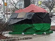
The Liberty Rock is a symbol of the history and culture of the African American community in St. Albans. The painting of the rock in red, black, and green, the colors of the Pan-African flag, represents the community's commitment to civil rights, group identity, and fostering ties between all people of African descent. The location of the rock, at the intersection of St. Albans and Hollis neighborhoods in Jamaica, highlights its significance as a shared symbol for the entire community. The Liberty Rock serves as a symbol of resistance and resilience, reminding the community of its rich cultural heritage and ongoing struggle for equality and justice.[61]
Education
_11_-_Eagle_Academy_III.jpg.webp)
St. Albans and Jamaica generally have a lower rate of college-educated residents than the rest of the city as of 2018. While 29% of residents age 25 and older have a college education or higher, 19% have less than a high school education and 51% are high school graduates or have some college education. By contrast, 39% of Queens residents and 43% of city residents have a college education or higher.[39]: 6 The percentage of St. Albans and Jamaica students excelling in math rose from 36% in 2000 to 55% in 2011, and reading achievement increased slightly from 44% to 45% during the same time period.[62]
St. Albans and Jamaica's rate of elementary school student absenteeism is more than the rest of New York City. In St. Albans and Jamaica, 22% of elementary school students missed twenty or more days per school year, higher than the citywide average of 20%.[40]: 24 (PDF p. 55) [39]: 6 Additionally, 74% of high school students in St. Albans and Jamaica graduate on time, about the same as the citywide average of 75%.[39]: 6
Schools
Public
Public schools are operated by the New York City Department of Education (NYCDOE). St. Albans contains the following public elementary schools which serve grades PK-5 unless otherwise indicated:
The following public middle schools serve grades 6-8:
Eagle Academy for Young Men III, a combined public middle and high school, serves grades 6-12.[68]
Private and charter
There are three charter schools:
- Riverton Street Charter School St. Albans
- Success Academy Springfield Gardens
- Achievement First Legacy Elementary School
Private schools include:
- St. Albans Christian Academy
- True Deliverance Christian School
- St. Catherine of Sienna Catholic School (opened 1929, closed 2009,[69] now site of Riverton Street Charter School)
Library
The Queens Public Library operates the St.Albans branch at 191-05 Linden Boulevard.[70]
Transportation
Numerous MTA bus lines run through the neighborhood, including the Q3, Q4, Q5, Q42, Q77, Q83, Q84, Q85, X63, and X64 all of which connect to the New York City Subway and the Long Island Rail Road (LIRR) at Jamaica Center and Jamaica, respectively.[71] The LIRR's St. Albans station serves the neighborhood.
Notable people
St. Albans was home to many artists of the jazz, hip hop, and rap music genres. The following notable people are known to have lived in the area:
|
Music
|
Sports
Other
|
Jazz legacy
Famous stride pianist Fats Waller was the first well-known musician to move into Addisleigh Park at the peak of his career in the late 1930s. Waller had grown up in the Church (his father was a pastor).[99] He subsequently had his home in Addisleigh Park fashioned with a built-in Hammond organ.[100] He died in 1943 from bronchial pneumonia.
In 1937, jazz pianist and bandleader Count Basie moved his orchestra from Kansas City to New York. Count Basie's orchestra performed at world-famous Manhattan venues including the Roseland Ballroom, the Savoy Ballroom, and the Woodside Hotel. In 1946, Basie and his wife, Katy, bought a home in Addisleigh Park, where the couple lived until 1973 when it was sold to bandleader/singer/pianist, Robert (Bubber) Johnson.[101]
Singer, film actress, and Civil Rights Activist Lena Horne also moved into the Addisleigh Park neighborhood in the year 1946. Soon after Horne, jazz trumpeter and bandleader Mercer Ellington, son of jazz great Duke Ellington, moved into Addisleigh Park in 1948. Eight years earlier, he had worked for renowned jazz trumpeter Cootie Williams as his road manager. Cootie Williams bought a home in Addisleigh Park in 1947.[102] While residing in Addisleigh Park, Mercer Ellington employed Dizzy Gillespie, Kenny Dorham, and Charles Mingus. Throughout the 1940s, Mercer and his father, Duke Ellington, frequently borrowed musicians from one another's ensembles.
Saxophonist Earl Bostic moved to Addisleigh Park in 1948, the same year Bostic's sextet hit success with their first single “Temptation”.[103] Bostic was born in Tulsa, Oklahoma. In the early 1930s, he played with Midwestern territory bands before moving to New York City in 1938 to play with Don Redman. Bostic's second hit, “Flamingo,” was produced in 1951, while he was still living in Addisleigh Park. In 1956, Bostic and his wife left Addisleigh Park to settle in Los Angeles. Earl Bostic died onstage from a heart attack in Rochester, New York, in 1965.
Bostic's neighbors on Murdock Avenue were Ella Fitzgerald and her then-husband, famous bassist and cellist Ray Brown. Fitzgerald owned her Addisleigh Park home from 1949 until 1956.[104] During the late 1930s and early 1940s, Fitzgerald had become one of the most recognizable names of wide-release swing music in the United States. She met Brown in 1946 while on tour with Dizzy Gillespie's band.[105] The couple divorced in 1952.[105] Between the years 1949 and 1956, Fitzgerald sang scat with various bebop bands. She was awarded the Presidential Medal of Freedom by President George H. W. Bush in 1992.[106]
Vicksburg, Mississippi native and famous jazz bassist Milt Hinton moved into Addisleigh Park in 1950.[100] In his younger years, he had lived and worked in Chicago alongside celebrated jazz musicians Art Tatum and Eddie South. He moved to New York City for a job in Cab Calloway's orchestra in 1936. Hinton bought a home on 113th Avenue in Addisleigh Park in 1950. He lived in the neighborhood until his death in 2000.
Saxophonist John Coltrane bought a home on Mexico Street in Addisleigh Park in the year 1959.[107] Coltrane had just met tremendous critical success after his collaborations with Thelonious Monk and Miles Davis. In January 1960, Coltrane released Giant Steps, his first album with Atlantic Records. Giant Steps is considered to be the album that catapulted Coltrane into jazz legend.
See also
References
Notes
- ↑ The name Foch was chosen to honor Marshal Ferdinand Foch, following World War I.[8] While most of Foch Boulevard still exists, the alignment east of Farmers Boulevard is now part of Linden Boulevard.[9]
Citations
- 1 2 "NYC Planning | Community Profiles". communityprofiles.planning.nyc.gov. New York City Department of City Planning. Retrieved April 7, 2018.
- 1 2 Table PL-P5 NTA: Total Population and Persons Per Acre - New York City Neighborhood Tabulation Areas*, 2010, Population Division - New York City Department of City Planning, February 2012. Accessed June 16, 2016.
- 1 2 Table PL-P3A NTA: Total Population by Mutually Exclusive Race and Hispanic Origin - New York City Neighborhood Tabulation Areas*, 2010, Population Division - New York City Department of City Planning, March 29, 2011. Accessed June 14, 2016.
- ↑ "Map of Queens neighborhoods". Archived from the original on August 22, 2008.
- 1 2 3 4 5 6 7 8 9 "Addisleigh Park Historic District Designation Report" (PDF). NYC.gov. Archived from the original (PDF) on February 24, 2017. Retrieved January 23, 2013.
- 1 2 "NYPD – 113th Precinct". www.nyc.gov. New York City Police Department. Retrieved October 3, 2016.
- ↑ Current City Council Districts for Queens County, New York City. Accessed May 5, 2017.
- ↑ "New Jamaica Final Maps". Brooklyn Daily Eagle. January 5, 1919. p. 44. Retrieved January 5, 2020 – via Brooklyn Public Library; newspapers.com
 .
. - 1 2 "Street Name Changes in Queens, NY (E to F)".
- ↑ "1929... News". Archived from the original on September 17, 2010. Retrieved March 29, 2010.
LOWERRE Secured Light Charles LOWERRE, treasurer of the St. Albans Lions Club, has succeeded in having the Police Department promise to put a traffic control light at the Foch and Farmers boulevard intersection at St. Albans.
- ↑ "Queens, New York". stevemorse.org. Archived from the original on January 4, 2020. Retrieved February 18, 2019.
- ↑ Gottlieb, Jeff (January 2006). "History of Jamaica" (PDF). Central Queens Historical Association. Archived from the original (PDF) on July 13, 2014. Retrieved October 17, 2009.
- ↑ "Baisley Pond Park". New York City Department of Parks and Recreation. Retrieved November 8, 2013.
- ↑ "1880 Census: sample Francis family in Queens". FamilySearch. Retrieved January 29, 2013.
Other records indicate at least some of these lived in an area then called Jamaica South and/or Springfield.
Francis households in Jamaica, Queens, in 1880 census
- 1890 Marriages and Deaths from the South Side Observer
- 1884 Jamaica Deaths
- Springfield Cemetery - pg 1
- Springfield Cemetery - pg 2
- Jamaica baptisms
- 1873 map of Town of Jamaica with a W. Francis living west of railroad tracks
- 1891 map of Town of Jamaica with a W. Francis living west of railroad tracks Archived June 7, 2011, at the Wayback Machine
- 1909 map showing a subdivision of Francis farm in the Addisleigh Park area Archived November 5, 2016, at the Wayback Machine - earlier subdivision east of the LIRR was called "The Terrace"
- 1 2 "1909 map". Archived from the original on June 7, 2011. Retrieved December 16, 2009. St Albans Avenue was name of 118th Ave east of 196th Street. (Francis Lewis Boulevard is not on the map.) Also, St. Albans Place was the name of 121st Road. (See Queens, NY, Street Name Changes 1914-May 1951.)
- ↑ "1910 map". Archived from the original on August 12, 2011. Retrieved December 17, 2009.
- ↑ "1898 map showing Locust Ave station in St. Albans on the Rockaway Branch of the LIRR". Archived from the original on March 20, 2009. Retrieved April 5, 2008.
{{cite web}}: CS1 maint: unfit URL (link) - ↑ "St.Albans Station photos". (This indicates trains stopped in 1897)
- ↑ Copquin, Claudia Gryvatz (2007). The neighborhoods of Queens. p. 193. ISBN 9780300112993.
- ↑ "St. Albans' New School House Dedicated Last Night". Brooklyn Eagle. December 12, 1895. Archived from the original on August 10, 2013. Retrieved November 22, 2019.. Mentions 1894 split from Hollis. See also full article and sketch of school: "Brooklyn Eagle" (PDF). December 12, 1895. Archived from the original (PDF) on March 20, 2009. Retrieved April 5, 2008.
- ↑ "Street Name Changes in Queens, NY : Old to New : R to S". Retrieved July 5, 2013.
- 1 2 "Queens Site Seized for Naval Hospital; Work Begun on St. Albans Golf Course as U.S. Files Notice". The New York Times. May 19, 1942. p. 4. ISSN 0362-4331. Retrieved January 11, 2020.
- 1 2 System, VA NY Harbor Healthcare (April 15, 2013). "Veterans Affairs". VA NY Harbor Health Care System. Retrieved January 12, 2020.
- ↑ "The New St. Albans Golf Course". Brooklyn Daily Eagle. June 25, 1914. p. 37. Retrieved January 9, 2020 – via Brooklyn Public Library; newspapers.com
 .
. - 1 2 Hirshon, Nicholas (April 8, 2008). "Queens building boom knocking out link to players like Babe Ruth". NY Daily News. Archived from the original on March 6, 2009. Retrieved March 17, 2009.
To build the U.S. Naval Hospital at Linden Blvd. and 179th St. in 1950, crews destroyed the historic St. Albans Golf Club, where Yankees icon Babe Ruth played regularly from the late 1920s through the 1940s.
See also:- http://www.protectsaintalbans.com/sitebuildercontent/sitebuilderfiles/ElectedRepresentativeSupportLetters.pdf%5B%5D
- http://www.addisleighpark.org/
- http://www.astorialic.org/starjournal/1940s/1942september_p.php Archived November 21, 2008, at the Wayback Machine
- http://select.nytimes.com/gst/abstract.html?res=F60612F93858157A93CBA8178ED85F468485F9
- http://select.nytimes.com/gst/abstract.html?res=F20A1EF83E59157A93C1A9178AD95F4C8485F9
- http://select.nytimes.com/gst/abstract.html?res=FB0F11F83C581B7B93C4A81789D85F478485F9
- ↑ "The late, great golf courses of Queens". New York Post. August 22, 2010. Retrieved January 11, 2020.
- ↑ "Hospital to Hold Fete; Naval Facility in St. Albans to Celebrate Its 17th Year". The New York Times. February 14, 1960. p. 71. ISSN 0362-4331. Retrieved March 12, 2023.
- ↑ "Navy Commissions Hospital in Queens; 10-Minute Ceremony in Minus 8 Temperature Marks Formal Opening at St. Albans". The New York Times. February 16, 1943. ISSN 0362-4331. Retrieved January 13, 2020.
- ↑ "Navy Naval Hospital Long Island, NY (St. Albans) | Navy Veteran Locator". navy.togetherweserved.com. Retrieved January 7, 2020.
- ↑ Berliner, David C. (March 10, 1974). "St. Albans Hospital Entering New Phase". The New York Times. ISSN 0362-4331. Retrieved January 7, 2020.
- ↑ Rabin, Bernard (October 22, 1976). "Dedicate VA Hospital in St. Albans Tomorrow". New York Daily News. p. 566. Retrieved January 9, 2020 – via newspapers.com
 .
. - ↑ "Roy Wilkins Recreation Center Highlights : NYC Parks". New York City Department of Parks & Recreation. June 26, 1939. Retrieved January 10, 2020.
- ↑ Speri, Alice (February 1, 2011). "Addisleigh Park, Historic Black Neighborhood in Queens, Gains Landmark Status". The New York Times. Retrieved June 20, 2014.
- ↑ Cowan, Jane. "Addisleigh Park: Enclave of Greats in African-American History, Wholly Intact 20th Century Garden City Suburb and Site of Important American Housing History" (PDF).
- ↑ "The Legacy of Addisleigh Park". The Root. Archived from the original on January 25, 2013. Retrieved January 23, 2013.
- ↑ "Queens Lots Lead in Suburban Sales". The New York Times. February 6, 1926.
- ↑ McNamara, Elizabeth. "New York's Finest Black Suburb". National Trust for Historic Preservation.
- ↑ "Historic Black Enclave in Queens Gains Landmark Status". New York Times. February 1, 2011. Retrieved January 22, 2013.
- 1 2 3 4 5 6 7 8 9 10 11 12 13 14 "Jamaica and Hollis (Including Hollis, Jamaica, Jamaica Center, North Springfield Gardens, Rochdale, South Jamaica and St. Albans)" (PDF). nyc.gov. NYC Health. 2018. Retrieved March 2, 2019.
- 1 2 "2016-2018 Community Health Assessment and Community Health Improvement Plan: Take Care New York 2020" (PDF). nyc.gov. New York City Department of Health and Mental Hygiene. 2016. Retrieved September 8, 2017.
- ↑ "New Yorkers are living longer, happier and healthier lives". New York Post. June 4, 2017. Retrieved March 1, 2019.
- ↑ "NYC-Queens Community District 12--Jamaica, Hollis & St. Albans PUMA, NY". Census Reporter. Retrieved July 17, 2018.
- ↑ Bilefsky, Dan (June 22, 2011). "Many Black New Yorkers Are Moving to the South". The New York Times. Retrieved March 1, 2019.
- ↑ "St. Albans and Jamaica – DNAinfo.com Crime and Safety Report". www.dnainfo.com. Archived from the original on April 15, 2017. Retrieved October 6, 2016.
- ↑ "St. Albans and South Jamaica – DNAinfo.com Crime and Safety Report". www.dnainfo.com. Archived from the original on October 10, 2016. Retrieved October 6, 2016.
- ↑ "113th Precinct CompStat Report" (PDF). www.nyc.gov. New York City Police Department. Retrieved July 22, 2018.
- ↑ "FDNY Firehouse Listing – Location of Firehouses and companies". NYC Open Data; Socrata. New York City Fire Department. September 10, 2018. Retrieved March 14, 2019.
- ↑ "Engine Company 275/Ladder Company 133". FDNYtrucks.com. Retrieved March 7, 2019.
- ↑ "Engine Company 317/Ladder Company 165/Battalion 54". FDNYtrucks.com. Retrieved March 7, 2019.
- ↑ Finkel, Beth (February 27, 2014). "Guide To Queens Hospitals". Queens Tribune. Archived from the original on February 4, 2017. Retrieved March 7, 2019.
- ↑ "Jamaica, New York City-Queens, New York Zip Code Boundary Map (NY)". United States Zip Code Boundary Map (USA). Archived from the original on October 19, 2018. Retrieved March 12, 2019.
- ↑ "Location Details: Saint Albans". USPS.com. Retrieved March 7, 2019.
- ↑ "Location Details: Rochdale Village". USPS.com. Retrieved March 7, 2019.
- ↑ "Maps : NYC Parks". New York City Department of Parks & Recreation. June 26, 1939. Retrieved June 12, 2019.
- ↑ "St. Albans Park Highlights : NYC Parks". New York City Department of Parks & Recreation. June 26, 1939. Retrieved January 8, 2020.
- ↑ "Roy Wilkins Recreation Center : NYC Parks". New York City Department of Parks and Recreation. Retrieved June 3, 2019.
- ↑ Fried, Joseph P. (August 3, 1985). "Queens Park Rises in Ruins of Wasteland". The New York Times. ISSN 0362-4331. Retrieved January 8, 2020.
- ↑ "Railroad Park Highlights : NYC Parks". New York City Department of Parks & Recreation. June 26, 1939. Retrieved January 8, 2020.
- ↑ "Daniel M. O'Connell Playground Highlights : NYC Parks". New York City Department of Parks & Recreation. June 26, 1939. Retrieved January 8, 2020.
- ↑ "Queens Public Library Digital".
- ↑ "Saint Albans | History of Queens, NY".
- ↑ "Jamaica/Hollis – QN 12" (PDF). Furman Center for Real Estate and Urban Policy. 2011. Retrieved October 5, 2016.
- ↑ "P.S. 015 Jackie Robinson". New York City Department of Education. Archived from the original on August 13, 2020. Retrieved January 8, 2020.
- ↑ "P.S. 036 Saint Albans School". New York City Department of Education. Archived from the original on October 23, 2020. Retrieved January 8, 2020.
- ↑ "P.S. 136 Roy Wilkins". New York City Department of Education. Archived from the original on June 19, 2022. Retrieved January 8, 2020.
- ↑ "I.S. 059 Springfield Gardens". New York City Department of Education. Archived from the original on June 19, 2022. Retrieved January 8, 2020.
- ↑ "I.S. 192 The Linden". New York City Department of Education. Archived from the original on October 21, 2020. Retrieved January 8, 2020.
- ↑ "Eagle Academy for Young Men III". New York City Department of Education. Archived from the original on October 26, 2020. Retrieved January 9, 2020.
- ↑ "List of Queens RC Parishes & Schools" (PDF). Retrieved June 19, 2013.
- ↑ "Branch Detailed Info: St.Albans". Queens Public Library. Retrieved March 7, 2019.
- ↑ "Queens Bus Map" (PDF). Metropolitan Transportation Authority. August 2022. Retrieved September 29, 2022.
- 1 2 3 Johnson, Kirk (February 2, 1997). "Black Workers Bear Big Burden As Jobs in Government Dwindle". The New York Times. Retrieved November 20, 2007.
Its roots and its reputation as New York's premier black middle class enclave go back further than that, to the 1940s, when Count Basie and Lena Horne and Jackie Robinson and Hal Jackson made their homes in St. Albans.
- 1 2 3 Cowan, Jane. "Addisleigh Park: Enclave of Greats in African-American History, Wholly Intact 20th Century Garden City Suburb and Site of Important American Housing History." Historic Districts Council (2008) . Accessed March 9, 2009.
- 1 2 3 4 5 6 7 8 9 Polland, Jennifer. "They May Have Played Harlem But They Lived Here". Queens Tribune. Archived from the original on January 4, 2009. Retrieved March 9, 2009.
- 1 2 3 4 5 6 Tarek, Shams (January 31, 2003). "Celebrating Black History Month: History Makers That Have Made A Mark On Southeast Queens". Southeast Queens Press. Archived from the original on July 6, 2015. Retrieved July 5, 2015.
- 1 2 3 4 5 6 7 8 9 10 "The Jazzmen of Queens". Retrieved March 9, 2009.
- 1 2 Tarek, Shams. "The Rebirth of Cool: A Jazz Renaissance In Southeast Queens". Southeast Queens Press. Archived from the original on June 4, 2009. Retrieved March 8, 2009.
- 1 2 3 4 5 6 7 "Queenswalk: A Look at St. Albans". Brownstoner Queens. May 22, 2013. Retrieved October 23, 2013.
- ↑ Plambeck, Joseph (December 5, 2008). "Bluesy Home Market With a Jazzy Past". The New York Times. ISSN 0362-4331. Retrieved March 12, 2023.
- ↑ Hamill, Denis. "Shine Light On Karl Grossman" Archived September 28, 2020, at the Wayback Machine, The Independent, February 11, 2020. "If you visit Fire Island on Valentine’s Day with someone special and marvel at the preserved natural beauty, give thanks that a gutsy kid reporter named Karl Grossman from St. Albans, Queens biked east as a young man because he fell in love with newspapering and a Long Island gal named Janet Kopp at Antioch College."
- ↑ "Digging For Weldon Irvine". docnrollfestival.com. Archived from the original on September 30, 2019. Retrieved August 10, 2020.
- ↑ Hess, Mickey (2009). Hip Hop in America: A Regional Guide. ABC-CLIO. p. 59. ISBN 0-31334-321-7.
- ↑ "***HERB KENNYthe INK SPOTS***". inkspots.ca. Retrieved February 18, 2019.
- ↑ Ettelson, Robbie (December 5, 2016). "The Triumphs and Tragedies of Larry Smith". medium.com. Cuepoint. Retrieved June 7, 2020.
- ↑ "biography at African American Registry". Archived from the original on December 27, 2010. Retrieved June 19, 2013.
- 1 2 "Famous residents of St. Albans, New York". P.S.36Q, The St. Albans School. Archived from the original on October 29, 2013. Retrieved October 23, 2013.
- ↑ "1955 TIME article on Campanella". Time. August 8, 1955. Archived from the original on August 10, 2013. Retrieved May 24, 2010.
- ↑ "Bob Cousy Timeline" (PDF). College of the Holy Cross. Retrieved April 7, 2012.
- ↑ "Ottawa Citizen - Google News Archive Search". news.google.com. Retrieved February 18, 2019.
- ↑ Heinz, W.C. (November 1960). "The Floyd Patterson His Friends Know". SPORT magazine. Archived from the original on December 4, 2008. Retrieved December 20, 2008.
- ↑ Phillips, Harry (March 18, 1957). "Memo From The Publisher". Sports Illustrated. Retrieved December 20, 2008.
- ↑ "Ruth, Gehrig play ball in Woodhaven". Queens Chronicle. October 12, 1928. Retrieved May 13, 2018.
- ↑ Keepnews, Peter. "His Big Break Canceled, Comic Adapts", The New York Times, March 31, 2005. Accessed June 12, 2023. "Mr. Bodden, 42, who begins a four-night headlining engagement at Carolines on Broadway tonight, is a former jet mechanic from St. Albans, Queens."
- ↑ "Encarta article on Fisher". Archived from the original on August 29, 2009. Retrieved July 5, 2013.
- ↑ Costella, AnnMarie. "Ex-St. Albans man takes part in history project; New exhibit documents experiences of former Brooklyn Navy Yard workers", Queens Chronicle, November 3, 2011.Accessed March 11, 2023. "Clarence Irving Sr., 87, a former St. Albans resident, is among dozens of Brooklyn Navy Yard workers whose stories and experiences are featured in an oral history project to be unveiled next week at the facility, where shipbuilding began after the American Revolution and which in its heyday sprawled over 200 acres."
- ↑ Ambrose, David. "Alex Katz's Early Drawings Reveal His Potential", Whitehot, June 2017. Accessed November 18, 2023. "Many of these drawings were made while riding the E Line from his families’ home in St. Alban’s, Queens to the East Village and back."
- ↑ "They Came from Queens". Archived from the original on February 4, 2008. Retrieved March 9, 2009.
- ↑ Marzlock, Ron. "Joan Vohs became a stunner here in St. Albans", Queens Chronicle, March 24, 2022. Accessed November 18, 2023. "The childhood home of actress and model Joan Vohs at 118-31 198 St. in St. Albans, as it looked in the 1940s."
- ↑ DeVeaux, Scott (2009). Jazz. W. W. Norton. p. 170.
- 1 2 "Addisleigh Park". Forgotten New York. 2014. Retrieved June 20, 2014.
- ↑ Adams, Michael Henry (May 17, 2010). "Protecting the House Where Lena Lived!". The Huffington Post. Retrieved June 20, 2014.
- ↑ Meeks, Gregory W. (March 1, 2007). "Black History Month". Congressional Record. 153 (4): 5234. ISBN 9780160869761.
- ↑ "178-16 Murdock Avenue, Home of Earl Bostic", Historic Districts Council (2014). Accessed June 20, 2014.
- ↑ "179-07 Murdock Avenue, Home of Ella Fitzgerald and Ray Brown", Historic Districts Council (2014). Accessed June 20, 2014.
- 1 2 "The Official Web Site of Ella Fitzgerald: Biography". ellafitzgerald.com. 2013. Archived from the original on June 27, 2012. Retrieved June 20, 2014.
- ↑ "Change-maker in black history: Ella Fitzgerald". Do Something. 2014. Archived from the original on May 18, 2013. Retrieved June 20, 2014.
- ↑ Porter, Lewis (1999). John Coltrane: His Life and Music. University of Michigan Press. p. 139. ISBN 0-472-10161-7.
Further reading
- "This Green and Pleasant Land" by Bryan Greene, in Poverty and Race, page 3.
- "St. Albans Lot Sale", Brooklyn Eagle, June 30, 1902
- 1990 Population Demographics
- 1898 map of area shows Baisley Blvd, Farmers Blvd, Linden Blvd, and LIRR line which runs through St. Albans
- More on famous residents, including former addresses
- Excerpts from To Stand and Fight: The Struggle for Civil Rights in Postwar New York City by Martha Biondi
External links
 Media related to St. Albans, Queens at Wikimedia Commons
- Queens Jazz Trail
- Jazz Tour of Queens

