Salgueiro | |
|---|---|
 Flag  Coat of arms | |
 Salgueiro Location in Brazil | |
| Coordinates: 8°4′27″S 39°7′9″W / 8.07417°S 39.11917°W | |
| Country | Brazil |
| Region | Northeast |
| State | Pernambuco |
| Area | |
| • Total | 1,687 km2 (651 sq mi) |
| Population (2020 [1]) | |
| • Total | 61,249 |
| • Density | 36/km2 (94/sq mi) |
| Time zone | UTC−3 (BRT) |
Salgueiro is a city in Pernambuco, Brazil. It is located in the mesoregion of Sertão Pernambucano . Salgueiro covers an area of 1687 square kilometers and had in 2020 an estimated population of 61,249 inhabitants.
It is the see city of the Roman Catholic Diocese of Salgueiro, a suffragan see of the Roman Catholic Archdiocese of Olinda e Recife.
Geography
- State - Pernambuco
- Region - Sertão Pernambucano
- Boundaries - Ceará (N); Belém de São Francisco (S), Verdejante, Mirandiba and Carnaubeira da Penha (E); Cabrobó, Terra Nova, Serrita and Cedro (W)
- Area - 1639.3 km2
- Elevation - 420 m
- Hydrography - Terra Nova River
- Vegetation - Forest Subcaducifólia.
- Climate - Semi desertic, ( Sertão) - hot and dry
- Main road - BR 232
- Distance to Recife - 510 km
Economy

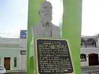
Major Raimundo de Sá Bust-statue
The main economic activities in Salgueiro are based in general commerce and agribusiness, especially plantations of onions, cotton and tomatoes; and creations of cattle, goats, sheep and pigs.
Economic Indicators
| Population | GDP x(1000 R$).[2] | GDP pc (R$) | PE |
|---|---|---|---|
| 55.435 | 236.166 | 4.442 | 0.39% |
Economy by Sector 2006
| Primary sector | Secondary sector | Service sector |
|---|---|---|
| 3.54% | 14.55% | 81.91% |
Health Indicators
| HDI (2000) | Hospitals (2007) | Hospitals beds (2007) | Children's Mortality every 1000 (2005) |
|---|---|---|---|
| 0.708 | 3 | 301 | 24.4 |
References
This article is issued from Wikipedia. The text is licensed under Creative Commons - Attribution - Sharealike. Additional terms may apply for the media files.
