Santo Antônio do Pinhal | |
|---|---|
Municipality | |
 Flag  Coat of arms | |
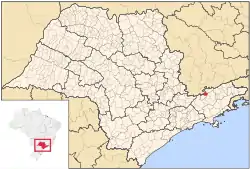
 Location in São Paulo state | |
 Santo Antônio do Pinhal Location in Brazil | |
| Coordinates: 22°49′38″S 45°39′45″W / 22.82722°S 45.66250°W | |
| Country | |
| Region | Southeast Brazil |
| State | São Paulo |
| Metropolitan Region | Vale do Paraíba e Litoral Norte |
| Area | |
| • Total | 133.01 km2 (51.36 sq mi) |
| Elevation | 1,080 m (3,540 ft) |
| Population (2020 [1]) | |
| • Total | 6,827 |
| • Density | 51/km2 (130/sq mi) |
| Time zone | UTC−3 (BRT) |
Santo Antônio do Pinhal is a municipality in the state of São Paulo in Brazil. It is part of the Metropolitan Region of Vale do Paraíba e Litoral Norte.[2] The population is 6,827 (2020 est.) in an area of 133.01 km².[3] The elevation is 1,080 m (3543 ft). It is situated near Campos do Jordão, some 150 km away from São Paulo.
The municipality contains 34% of the 39,800 hectares (98,000 acres) Sapucaí Mirim Environmental Protection Area, created in 1998.[4]
References
- ↑ IBGE 2020
- ↑ Assembleia Legislativa do Estado de São Paulo, Lei Complementar Nº 1.166
- ↑ Instituto Brasileiro de Geografia e Estatística
- ↑ APA Sapucaí-Mirim (in Portuguese), ISA: Instituto Socioambiental, retrieved 2016-10-02
External links
This article is issued from Wikipedia. The text is licensed under Creative Commons - Attribution - Sharealike. Additional terms may apply for the media files.