Saraburi
สระบุรี | |
|---|---|
 | |
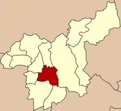
 Location in Saraburi Province | |
| Country | Thailand |
| Province | Saraburi Province |
| District | Amphoe Mueang Saraburi |
| Area | |
| • Land | 7.8 sq mi (20.1 km2) |
| Population (2020) | |
| • Total | 60,809 |
| Time zone | UTC+7 (ICT) |
| Website | http://www.tmsbr.go.th |
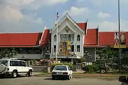
Saraburi City (thesaban mueang) is the provincial capital of Saraburi Province in central Thailand.[1][2] In 2020, it had a population of 60,809 people, and covers the complete tambon Pak Phriao of the Mueang Saraburi district.
Location
Saraburi sits on the banks of the Pa Sak River, around 60 km upstream from the confluence with the Chao Phraya River and around 60 km downstream from the Pasak Chonlasit Dam.
The city is around 100 km northeast of Bangkok, 40 km northeast of Phra Nakhon Sri Ayutthaya, and 50 km west of Khao Yai National Park.
History
Saraburi was founded in 1549 as a base for troop recruitment by King Maha Chakkraphat due to the threat of the growing Burmese Toungoo Dynasty.[3]
In 1624, Wat Phra Phutthabat was built by King Songtham of Ayutthaya on the city.
The royal decree established the Saraburi Municipality on 10 December 1835 with an area of 5 square kilometers.[4]
Demographics
Since 2005, the population of Saraburi has been fluctuating up and down, however, the city's population in 2005 is greater than what it is as of 2020.[5]
| Estimation date | 31 Dec 2005 | 31 Dec 2010 | 31 Dec 2015 | 31 Dec 2019 |
|---|---|---|---|---|
| Population | 61,900 | 63,554 | 61,840 | 60,809 |
References
- ↑ "Saraburi | To Do & See | How to get there". www.renown-travel.com. Retrieved 17 January 2019.
- ↑ "Sara Buri City - City". RouteYou. Retrieved 17 January 2019.
- ↑ "The official website of Tourism Authority of Thailand".
- ↑ "สภาพทั่วไปของเทศบาล" (in Thai). Archived from the original on 7 November 2016. Retrieved 13 June 2023.
{{cite web}}: CS1 maint: unfit URL (link) - ↑ "THAILAND: Major Cities, Towns & Communes".
External links
 Saraburi travel guide from Wikivoyage