| City of Kalamunda Western Australia | |||||||||||||||
|---|---|---|---|---|---|---|---|---|---|---|---|---|---|---|---|
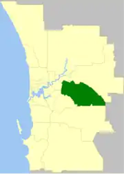
 The City of Kalamunda within the Perth Metropolitan Area | |||||||||||||||
| Population | 58,762 (LGA 2021)[1] | ||||||||||||||
| Established | 1897 | ||||||||||||||
| Area | 324.2 km2 (125.2 sq mi) | ||||||||||||||
| Mayor | Margaret Thomas[2] | ||||||||||||||
| Council seat | Kalamunda | ||||||||||||||
| Region | Eastern Metropolitan Perth Darling Scarp | ||||||||||||||
| State electorate(s) | Darling Range, Forrestfield, Kalamunda | ||||||||||||||
| Federal division(s) | Hasluck, Pearce | ||||||||||||||
 | |||||||||||||||
| Website | City of Kalamunda | ||||||||||||||
| |||||||||||||||
The City of Kalamunda is a local government area in the eastern metropolitan region of the Western Australian capital city of Perth about 25 kilometres (16 mi) east of Perth's central business district. The area covers 324 square kilometres (125 sq mi), much of which is state forest rising into the Darling Scarp to the east. As of 2021, the city had a population of 58,762.
History
The Darling Range Road District was gazetted on 30 April 1897. On 1 July 1961, it became the Shire of Kalamunda after the enactment of the Local Government Act 1960, which reformed all remaining road districts into shires.[3] The Shire of Kalamunda commenced community consultation on whether to become a city in 2015, and was renamed the City of Kalamunda on 1 July 2017.[4][5][6]
Wards
The city is divided into four wards.
- North Ward (three councillors)
- North West Ward (three councillors)
- South East Ward (three councillors)
- South West Ward (three councillors)
Suburbs
The suburbs of the City of Kalamunda with population and size figures based on the most recent Australian census:[7][8]
| Suburb | Population | Area | Map |
|---|---|---|---|
| Bickley | 713 (SAL 2021)[9] | 9.9 km2 (3.8 sq mi) | |
| Canning Mills | 26 (SAL 2016)[10][11] | 33.5 km2 (12.9 sq mi) | |
| Carmel | 754 (SAL 2021)[12] | 11.6 km2 (4.5 sq mi) | |
| Forrestfield | 13,181 (SAL 2021)[13] | 17.4 km2 (6.7 sq mi) | |
| Gooseberry Hill | 3,323 (SAL 2021)[14] | 8.9 km2 (3.4 sq mi) | |
| Hacketts Gully | 55 (SAL 2021)[15] | 12.2 km2 (4.7 sq mi) | |
| High Wycombe | 12,198 (SAL 2021)[16] | 10.5 km2 (4.1 sq mi) | |
| Kalamunda | 7,163 (SAL 2021)[17] | 10.6 km2 (4.1 sq mi) | |
| Lesmurdie | 8,413 (SAL 2021)[18] | 13.6 km2 (5.3 sq mi) | |
| Maida Vale | 4,499 (SAL 2016)[19][20] | 8.4 km2 (3.2 sq mi) | |
| Paulls Valley | 83 (SAL 2021)[21] | 20.3 km2 (7.8 sq mi) | |
| Perth Airport * | 25 (SAL 2021)[22] | 19.2 km2 (7.4 sq mi) | |
| Pickering Brook | 579 (SAL 2021)[23] | 104.6 km2 (40.4 sq mi) | |
| Piesse Brook | 214 (SAL 2021)[24] | 10.2 km2 (3.9 sq mi) | |
| Reservoir | 0 (SAL 2021)[25] | 39.6 km2 (15.3 sq mi) | |
| Walliston | 1,016 (SAL 2021)[26] | 3.8 km2 (1.5 sq mi) | |
| Wattle Grove | 6,547 (SAL 2021)[27] | 8 km2 (3.1 sq mi) |
( * indicates suburb partially located within City)
Population
|
|
Heritage listed places
As of 2023, 259 places are heritage-listed in the City of Kalamunda,[28] of which 17 are on the State Register of Heritage Places, among them Perth Observatory and the Statham's Quarry.[29]
References
- ↑ Australian Bureau of Statistics (28 June 2022). "Kalamunda (Local Government Area)". Australian Census 2021 QuickStats. Retrieved 28 June 2022.
- ↑ "2023 Ordinary Election - Kalamunda". www.elections.wa.gov.au. Western Australian Electoral Commission. 2023. Retrieved 5 November 2023.
- ↑ "Municipality Boundary Amendments Register" (PDF). Western Australian Electoral Distribution Commission. Retrieved 11 January 2020.
- ↑ "Shire of Kalamunda City Kalamunda". 29 June 2017.
- ↑ "Shire of Kalamunda - Kalamunda Achieves City Status". www.kalamunda.wa.gov.au. Archived from the original on 2 August 2017.
- ↑ "Shire of Kalamunda - Becoming a City". Archived from the original on 2 August 2017. Retrieved 1 August 2017.
- ↑ "SLIP Map". maps.slip.wa.gov.au. Landgate. Retrieved 1 January 2023.
- ↑ "NationalMap". nationalmap.gov.au. Geoscience Australia. Retrieved 1 January 2023.
- ↑ Australian Bureau of Statistics (28 June 2022). "Bickley (suburb and locality)". Australian Census 2021 QuickStats. Retrieved 28 June 2022.
- ↑ Australian Bureau of Statistics (27 June 2017). "Canning Mills (suburb and locality)". Australian Census 2016.
- ↑ Australian Bureau of Statistics (27 June 2017). "Canning Mills (suburb and locality)". Australian Census 2016 QuickStats. Retrieved 28 June 2022.
- ↑ Australian Bureau of Statistics (28 June 2022). "Carmel (suburb and locality)". Australian Census 2021 QuickStats. Retrieved 28 June 2022.
- ↑ Australian Bureau of Statistics (28 June 2022). "Forrestfield (suburb and locality)". Australian Census 2021 QuickStats. Retrieved 28 June 2022.
- ↑ Australian Bureau of Statistics (28 June 2022). "Gooseberry Hill (suburb and locality)". Australian Census 2021 QuickStats. Retrieved 28 June 2022.
- ↑ Australian Bureau of Statistics (28 June 2022). "Hacketts Gully (suburb and locality)". Australian Census 2021 QuickStats. Retrieved 28 June 2022.
- ↑ Australian Bureau of Statistics (28 June 2022). "High Wycombe (suburb and locality)". Australian Census 2021 QuickStats. Retrieved 28 June 2022.
- ↑ Australian Bureau of Statistics (28 June 2022). "Kalamunda (suburb and locality)". Australian Census 2021 QuickStats. Retrieved 28 June 2022.
- ↑ Australian Bureau of Statistics (28 June 2022). "Lesmurdie (suburb and locality)". Australian Census 2021 QuickStats. Retrieved 28 June 2022.
- ↑ Australian Bureau of Statistics (27 June 2017). "Maida Vale (suburb and locality)". Australian Census 2016.
- ↑ Australian Bureau of Statistics (27 June 2017). "Maida Vale (suburb and locality)". Australian Census 2016 QuickStats. Retrieved 28 June 2022.
- ↑ Australian Bureau of Statistics (28 June 2022). "Paulls Valley (suburb and locality)". Australian Census 2021 QuickStats. Retrieved 28 June 2022.
- ↑ Australian Bureau of Statistics (28 June 2022). "Perth Airport (suburb and locality)". Australian Census 2021 QuickStats. Retrieved 28 June 2022.
- ↑ Australian Bureau of Statistics (28 June 2022). "Pickering Brook (suburb and locality)". Australian Census 2021 QuickStats. Retrieved 28 June 2022.
- ↑ Australian Bureau of Statistics (28 June 2022). "Piesse Brook (suburb and locality)". Australian Census 2021 QuickStats. Retrieved 28 June 2022.
- ↑ Australian Bureau of Statistics (28 June 2022). "2021 Reservoir (WA), Census All persons QuickStats | Australian Bureau of Statistics (suburb and locality)". Australian Census 2021 QuickStats. Retrieved 28 June 2022.
- ↑ Australian Bureau of Statistics (28 June 2022). "Walliston (suburb and locality)". Australian Census 2021 QuickStats. Retrieved 28 June 2022.
- ↑ Australian Bureau of Statistics (28 June 2022). "Wattle Grove (WA) (suburb and locality)". Australian Census 2021 QuickStats. Retrieved 28 June 2022.
- ↑ "City of Kalamunda Heritage Places". inherit.stateheritage.wa.gov.au. Heritage Council of Western Australia. Retrieved 18 February 2023.
- ↑ "City of Kalamunda State Register of Heritage Places". inherit.stateheritage.wa.gov.au. Heritage Council of Western Australia. Retrieved 18 February 2023.