 | |
| Former names | Stade Géo André (1942–1963) |
|---|---|
| Location | Tunis, Tunisia |
| Capacity | 18,000[1] |
| Surface | Grass |
| Construction | |
| Built | 1942 |
| Renovated | 2009–2012 |
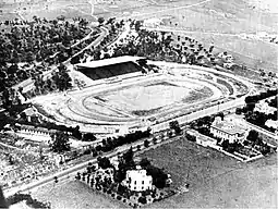
Chedly Zouiten Stadium is a multi-purpose stadium in the Mutuelleville district of Tunis, Tunisia.[1] It is currently used by football team Stade Tunisien.[2] The stadium holds 18,000 people.[1]
It hosted the 1965 Africa Cup of Nations. It was renovated for two meetings of the 1994 Africa Cup of Nations. Long the main stadium in the capital, it was supplanted by the Stade El Menzah in 1967 and then by the Stade 7 November of Radès in 2001, both larger and more modern.
Name

It was named as Stade Géo André, who was a French sportsman killed by German forces during the Tunisian campaign of World War II, before being renamed in honour of Chedly Zouiten, a figure of Tunisian football and a relative of President Habib Bourguiba after the independence of Tunisia from France.
Renovation
The municipality of Tunis closed it on 17 November 2006 to carry out renovation work estimated at 3.4 million dinars and initially caused by faults in the rainwater drainage channels. This cost includes the renovation of the sanitation and drainage network for rainwater, the renovation of the grandstand, the press stand, bleachers on the lawn side, changing rooms, electrical installations; the works were launched on 2 January 2009 for a period of ten months. It was not until 20 May 2012 that the stadium was finally reopened.
Equipment
The stadium houses two grass football pitches, one for training and the other for national and international sports competitions, a handball field, a 400-metre track, two jumping pits, two shooting ranges and a steeple river.
Citations
References
- "Complexes sportifs". Municipalité de Tunis - الشباب والرياضة (in French). n.d. Archived from the original on 23 November 2014. Retrieved 23 November 2014.