State Highway 31 | ||||
|---|---|---|---|---|
 | ||||
| Route information | ||||
| Maintained by ODOT | ||||
| Length | 132.6 mi (213.4 km) | |||
| Major junctions | ||||
| West end | ||||
| East end | ||||
| Location | ||||
| Country | United States | |||
| State | Oklahoma | |||
| Highway system | ||||
| ||||
| ||||

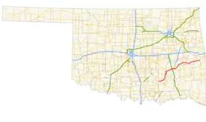
State Highway 31 (abbreviated SH-31) is a state highway in Oklahoma. It runs 132.6 miles[1] in an irregular west-to-east pattern in the southeastern part of the state.
There are two spur highways branching from SH-31, SH-31A and SH-31B.
Route description
SH-31 begins at SH-48 seven miles (11 km) south of Tupelo. Two miles (3.2 km) east of here, SH-31B branches off, connecting the main highway with the town of Olney. SH-31 then continues for 10 miles (16 km) to Coalgate, the seat of Coal County, where it intersects US-75/SH-3. Leaving Coalgate, SH-31 turns north at SH-131, traveling 22 miles (35 km) to its junction with SH-31A, which connects with US-270 at Stuart. At SH-31A, SH-31 turns to the east, following the northern edge of the McAlester Army Ammunition Plant, arriving in McAlester, seat of Pittsburg County, 22 miles (35 km) later.[2]
In McAlester, SH-31 forms a five-mile (8 km) concurrency with US-270 and SH-1, splitting up just east of the US-69 interchange on the east side of the city. SH-31 then sets off to the northeast, passing through Krebs, and crossing the south arm of Lake Eufaula.[2]
At Quinton, 27 miles (43 km) from McAlester, SH-31 serves as the southern terminus of SH-71, then heads east, forming a six-mile (10 km) concurrency with SH-2 to the town of Kinta. At Kinta, SH-2 turns north, and SH-31 continues east, with a short dogleg concurrency with SH-82 at Lequire. Continuing on to the east, SH-31 serves as the southern terminus for SH-26 at McCurtain, then passes through Bokoshe before terminating at US-59/US-271, two miles (3 km) north of Panama.[2]
Junction list
| County | Location | mi[1] | km | Destinations | Notes | |||
|---|---|---|---|---|---|---|---|---|
| Coal | | 0.0 | 0.0 | Western terminus | ||||
| | 2.0 | 3.2 | Northern terminus of SH-31B | |||||
| Coalgate | 11.5 | 18.5 | Western end of US-75/SH-3 concurrency | |||||
| 11.6 | 18.7 | Eastern end of US-75/SH-3 concurrency | ||||||
| Cairo | 17.1 | 27.5 | Western terminus of SH-131 | |||||
| Pittsburg |
No major junctions | |||||||
| Hughes | | 39.0 | 62.8 | Southern terminus of SH-31A | ||||
| Pittsburg | McAlester | 60.9 | 98.0 | Western end of US-270/OK-1 concurrency | ||||
| 62.7 | 100.9 | |||||||
| 63.4 | 102.0 | Eastern end of US-270/OK-1 concurrency | ||||||
| Quinton | 90.8 | 146.1 | Southern terminus of SH-71 | |||||
| Haskell | | 92.9 | 149.5 | Western end of SH-2 concurrency | ||||
| Kinta | 98.6 | 158.7 | Eastern end of SH-2 concurrency | |||||
| Lequire | 106.4 | 171.2 | ||||||
| McCurtain | 115.1 | 185.2 | Southern terminus of SH-26 | |||||
| Le Flore | | 132.6 | 213.4 | Eastern terminus | ||||
1.000 mi = 1.609 km; 1.000 km = 0.621 mi
| ||||||||
Spur routes
SH-31A
State Highway 31A | |
|---|---|
| Location | Pittsburg and Hughes counties |
| Length | 4.46 mi[3][4] (7.18 km) |
SH-31A is a 4.46-mile (7.18 km) spur connecting SH-31 with US-270/SH-1 and the town of Stuart in Pittsburg and Hughes counties.[3][4]
SH-31B
State Highway 31B | |
|---|---|
| Location | Olney |
| Length | 3.44 mi[5] (5.54 km) |
SH-31B is a 3.44-mile (5.54 km) spur connecting SH-31 and the town of Olney in Coal County.[5]
References
- 1 2 Stuve, Eric. "OK-31". OKHighways.com.
- 1 2 3 Official State Map (PDF) (Map) (2009–10 ed.). Oklahoma Department of Transportation. Retrieved 2010-03-21.
- 1 2 Oklahoma Department of Transportation (n.d.). Control Section Maps: Pittsburg County (PDF) (Map) (2012–2013 ed.). Scale not given. Oklahoma City: Oklahoma Department of Transportation. Retrieved 2014-03-23.
- 1 2 Oklahoma Department of Transportation (n.d.). Control Section Maps: Hughes County (PDF) (Map) (2012–2013 ed.). Scale not given. Oklahoma City: Oklahoma Department of Transportation. Retrieved 2014-03-23.
- 1 2 Oklahoma Department of Transportation (n.d.). Control Section Maps: Coal County (PDF) (Map) (2012–2013 ed.). Scale not given. Oklahoma City: Oklahoma Department of Transportation. Retrieved 2014-03-23.