State Route 65 | ||||
|---|---|---|---|---|
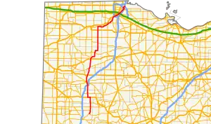 Route of SR 65 highlighted in red | ||||
| Route information | ||||
| Maintained by ODOT | ||||
| Length | 115.84 mi[1] (186.43 km) | |||
| Existed | 1924–present | |||
| Major junctions | ||||
| South end | ||||
| North end | ||||
| Location | ||||
| Country | United States | |||
| State | Ohio | |||
| Counties | Shelby, Auglaize, Allen, Putnam, Henry, Wood, Lucas | |||
| Highway system | ||||
| ||||
| ||||

State Route 65 (SR 65) is a north–south highway in western Ohio. Its southern terminus is at State Route 47 near Sidney, and its northern terminus is at its interchange with Interstate 280 in Toledo. From south to north, the route passes through the cities of Jackson Center, Uniopolis, Lima, Columbus Grove, Ottawa, Leipsic, Belmore, McClure, Grand Rapids, Perrysburg, Rossford, and Toledo.
Route 65 parallels the south bank of the Maumee River for its northernmost 32 miles, from east of Napoleon to Toledo.
History
State Route 65 is an original state highway. Its original southern terminus was at State Route 15 in Ottawa, and it crossed the Maumee River near Liberty Center, continuing northward to Delta and terminating at the Michigan state line.
In 1931, the route's northern terminus was moved to downtown Toledo along its current route. Most of its former route north of the Maumee River is now that of State Route 109. From 1931 until 1989, State Route 65 did not cross the Maumee River. Until 1964, its route from Perrysburg to Toledo was superseded by U.S. Route 23.
In 1938, State Route 65's southern terminus was extended to its current terminus. It replaced the now defunct State Routes 33 and 318.
In 1989, when U.S. Route 223 was truncated back to Sylvania, State Route 65 was extended along its former route (along with State Route 51) across the Maumee on the Anthony Wayne Bridge. State Route 51 took U.S. Route 223's route on Monroe Street, while State Route 65 took the route of Summit Street from there to Interstate 280.
In June, 2007, the Veterans' Glass City Skyway opened, taking Interstate 280 across the Maumee. Subsequently, State Route 65 was rerouted onto the Robert Craig Memorial Bridge, the former crossing of Interstate 280 across the river, the week after the new bridge opened,[2] ending at the former Front Street interchange.
Major junctions
| County | Location | mi[1] | km | Destinations | Notes |
|---|---|---|---|---|---|
| Shelby | Salem Township | 0.00 | 0.00 | ||
| Jackson Township | 3.21 | 5.17 | Eastern terminus of SR 119 | ||
| Jackson Center | 6.21 | 9.99 | |||
| Auglaize | Clay Township | 10.37 | 16.69 | Western terminus of SR 720 | |
| Clay–Union township line | 14.48 | 23.30 | Southern end of US 33 concurrency | ||
| 16.53 | 26.60 | Northern end of US 33 concurrency | |||
| Uniopolis | 19.72 | 31.74 | |||
| Allen | Lima–Perry Township municipal line | 26.37– 26.45 | 42.44– 42.57 | Exit 122 (I-75) | |
| Lima | 29.15 | 46.91 | Southern end of SR 117 / SR 309 concurrencies | ||
| 29.37 | 47.27 | Northern end of SR 117 concurrency | |||
| 29.75 | 47.88 | Southern end of SR 81 concurrency | |||
| 29.94 | 48.18 | Northern end of SR 81 / SR 309 concurrencies | |||
| American–Bath township line | 33.81 | 54.41 | Southern terminus of SR 115 | ||
| Monroe Township | 35.73– 35.95 | 57.50– 57.86 | Interchange | ||
| Putnam | Columbus Grove | 42.45 | 68.32 | ||
| Ottawa | 49.70 | 79.98 | Southern end of SR 15 / SR 109 concurencies | ||
| 50.17 | 80.74 | Northern end of SR 15 concurrency | |||
| 50.45 | 81.19 | Northern end of SR 109 concurrency | |||
| Leipsic | 57.52 | 92.57 | |||
| Henry | Bartlow Township | 67.64 | 108.86 | Southern end of SR 18 concurrency | |
| 68.52 | 110.27 | Northern end of SR 18 concurrency | |||
| Richfield Township | 72.54 | 116.74 | |||
| McClure | 78.59 | 126.48 | |||
| Damascus Township | 81.61 | 131.34 | Eastern terminus of SR 110 | ||
| Wood | Grand Rapids | 85.96 | 138.34 | Southern terminus of SR 295 | |
| Washington Township | 90.60 | 145.81 | Northern terminus of SR 235 | ||
| Middleton Township | 93.28 | 150.12 | Western terminus of SR 582 | ||
| 96.14 | 154.72 | Southern end of SR 64 concurrency | |||
| 96.70 | 155.62 | Northern end of SR 64 concurrency | |||
| Perrysburg | 102.43 | 164.85 | Southern end of SR 25 concurrency | ||
| 102.69 | 165.26 | Northern end of SR 25 concurrency; southern end of US 20 concurrency | |||
| 103.36 | 166.34 | Northern end of US 20 concurrency | |||
| Lucas | Toledo | 109.54– 109.72 | 176.29– 176.58 | Exit 199 (I-75) | |
| 111.61 | 179.62 | Southern end of SR 2 / SR 51 concurrencies | |||
| Maumee River | Anthony Wayne Bridge | ||||
| Toledo | 112.41 | 180.91 | Northern end of SR 2 concurrency | ||
| 112.90 | 181.69 | Northern end of SR 51 concurrency | |||
| 113.45 | 182.58 | Eastern terminus of SR 120 | |||
| Maumee River | Craig Memorial Bridge | ||||
| Toledo | 115.01– 115.84 | 185.09– 186.43 | Exit 9 (I-280) | ||
1.000 mi = 1.609 km; 1.000 km = 0.621 mi
| |||||
References
- 1 2 "DESTAPE". Ohio Department of Transportation. July 16, 2013. Retrieved August 22, 2014.
- ↑ Weber, Laren (2007-06-17). "Beneath the beams, abutments, and concrete, Toledo's Maumee crossings have a story to tell". Toledo Blade. Retrieved 2009-08-27.