 | |
|---|---|
 | |
| Route information | |
| Part of | |
| Length | 156 km (97 mi) |
| Major junctions | |
| North end | Dereköy Checkpoint at the Bulgaria-Turkey border crossing |
| South end | Tekirdağ |
| Location | |
| Country | Turkey |
| Highway system | |
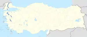
D.555 is a north to south state road running on the European part of Turkey. It starts in Dereköy Checkpoint at the Bulgaria-Turkey border crossing and ends in Tekirdağ at the ![]() D.110 junction. It is part of the European route E87 between its starting point and the D.100 junction in Babaeski.[1]
D.110 junction. It is part of the European route E87 between its starting point and the D.100 junction in Babaeski.[1]
Itinerary
| Province | Location | Distance from (km) | ||
|---|---|---|---|---|
| previous location | Dereköy CP | Tekirdağ | ||
| Kırklareli | Dereköy Checkpoint | 0 | 0 | 156 |
| Dereköy | 12 | 12 | 144 | |
| Pınarhisar | 29 | 41 | 115 | |
| Karacaoğlan | 24 | 65 | 91 | |
| Babaeski | 10 | 75 | 81 | |
| Tekirdağ | Hayrabolu | 32 | 107 | 49 |
| Banarlı | 30 | 137 | 19 | |
| Tekirdağ | 19 | 156 | 0 | |
| 1.000 mi = 1.609 km; 1.000 km = 0.621 mi | ||||
Intersections
References
- ↑ Türkiye Haritası (Map) (in Turkish). Karayolları Genel Müdürlüğü. Retrieved 2015-06-18.
External links
| East–west highways | ||
|---|---|---|
| North–south highways |
| |
Main highways highlighted | ||
This article is issued from Wikipedia. The text is licensed under Creative Commons - Attribution - Sharealike. Additional terms may apply for the media files.