| Szeben County | |
|---|---|
| County of the Kingdom of Hungary | |
| 1876–1920 | |
 Coat of arms
| |
 | |
| Capital | Nagyszeben |
| Area | |
| • Coordinates | 45°48′N 24°9′E / 45.800°N 24.150°E |
• 1910 | 3,619 km2 (1,397 sq mi) |
| Population | |
• 1910 | 176900 |
| History | |
• Established | 1876 |
| 4 June 1920 | |
| Today part of | Romania |
| Sibiu is the current name of the capital. | |
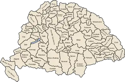
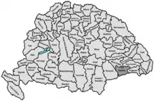
Szeben was an administrative county (comitatus) of the Kingdom of Hungary. Its territory is now in central Romania (southern Transylvania). The capital of the county was Nagyszeben (present-day Sibiu).
Geography
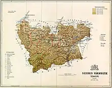
Szeben County shared borders with Romania and the Hungarian counties Hunyad, Alsó-Fehér, Nagy-Küküllő, and Fogaras. The river Olt flowed through the county. Its area was 3,619 km2 (1,397 sq mi) around 1910.
History
Szeben County was formed in 1876, when the administrative structure of Transylvania was changed. It included the former Saxon seats of Hermannstadt/Sibiu, Mühlbach/Sebeș, Reussmarkt/Miercurea, and (most of) Nocrich, as well as parts of Alsó-Fehér and Felső-Fehér counties. In 1920, by the Treaty of Trianon, the county became part of Romania. Its territory lies in the present Romanian counties Sibiu and Alba (the area around Sebeș).
Demographics

| Census | Total | Romanian | German | Hungarian | Other or unknown |
|---|---|---|---|---|---|
| 1880[1] | 141,627 | 90,802 (66.27%) | 40,723 (29.72%) | 2,991 (2.18%) | 2,497 (1.82%) |
| 1890[2] | 148,738 | 98,719 (66.37%) | 42,497 (28.57%) | 4,342 (2.92%) | 3,180 (2.14%) |
| 1900[3] | 166,188 | 108,413 (65.24%) | 47,678 (28.69%) | 8,084 (4.86%) | 2,013 (1.21%) |
| 1910[4] | 176,921 | 113,672 (64.25%) | 49,757 (28.12%) | 10,159 (5.74%) | 3,333 (1.88%) |
| Census | Total | Eastern Orthodox | Lutheran | Greek Catholic | Roman Catholic | Calvinist | Other or unknown |
|---|---|---|---|---|---|---|---|
| 1880 | 141,627 | 90,553 (63.94%) | 33,781 (23.85%) | 10,853 (7.66%) | 4,680 (3.30%) | 1,110 (0.78%) | 650 (0.47%) |
| 1890 | 148,738 | 88,365 (59.41%) | 39,065 (26.26%) | 12,550 (8.44%) | 6,414 (4.31%) | 1,586 (1.07%) | 758 (0.51%) |
| 1900 | 166,188 | 95,380 (57.39%) | 43,439 (26.14%) | 14,050 (8.45%) | 8,747 (5.26%) | 3,147 (1.89%) | 1,425 (0.86%) |
| 1910 | 176,921 | 99,952 (56.50%) | 45,912 (25.95%) | 16,064 (9.08%) | 9,503 (5.37%) | 3,528 (1.99%) | 1,962 (1.11%) |
Subdivisions
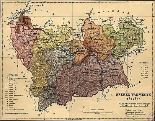
In the early 20th century, the subdivisions of Szeben county were:
| Districts (járás) | |
|---|---|
| District | Capital |
| Nagydisznód | Nagydisznód (now Cisnădie) |
| Nagyszeben | Nagyszeben (now Sibiu) |
| Szászsebes | Szászsebes (now Sebeș) |
| Szelistye | Szelistye (now Săliște) |
| Szerdahely | Szerdahely (now Miercurea Sibiului) |
| Újegyház | Újegyház (now Nocrich) |
| Urban districts (rendezett tanácsú város) | |
| Nagyszeben (now Sibiu) | |
| Szászsebes (now Sebeș) | |
Notes
References
- ↑ "Az 1881. év elején végrehajtott népszámlálás főbb eredményei megyék és községek szerint rendezve, II. kötet (1882)". library.hungaricana.hu. Retrieved 28 September 2021.
- ↑ "A Magyar Korona országainak helységnévtára (1892)". library.hungaricana.hu. Retrieved 29 September 2021.
- ↑ "A MAGYAR KORONA ORSZÁGAINAK 1900". library.hungaricana.hu. Retrieved 29 September 2021.
- ↑ "KlimoTheca :: Könyvtár". Kt.lib.pte.hu. Retrieved 29 September 2021.