| Tagus | |
|---|---|
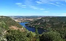
 View of Tagus River in Toledo, Spain | |
 Path of the Tagus through the Iberian Peninsula | |
| Etymology | Vulgar Latin taliāre, "to cut through" |
| Location | |
| Country | Spain, Portugal |
| Physical characteristics | |
| Source | Fuente de García, Montes Universales |
| • location | Frías de Albarracín, Spain |
| • coordinates | 40°19′16″N 1°41′49″W / 40.321°N 1.697°W |
| • elevation | 1,593 m (5,226 ft) |
| Mouth | Estuary of the Tagus, Atlantic Ocean |
• location | Lisbon, Portugal |
• coordinates | 38°41′28″N 9°10′16″W / 38.691°N 9.171°W |
• elevation | 0 m (0 ft) |
| Length | 1,007 km (626 mi) |
| Basin size | 80,100 km2 (30,900 sq mi) |
| Discharge | |
| • average | 500 m3/s (18,000 cu ft/s) |
| Basin features | |
| Tributaries | |
| • left | Guadiela, Algodor, Gévalo, Ibor, Almonte, Salor, Sever |
| • right | Gallo, Jarama, Guadarrama, Alberche, Tiétar, Alagón, Zêzere |
.jpg.webp)
The Tagus (/ˈteɪɡəs/ TAY-gəs; Spanish: Tajo [ˈtaxo]; Portuguese: Tejo [ˈtɛʒu]; see below) is the longest river in the Iberian Peninsula. The river rises in the Montes Universales near Teruel, in mid-eastern Spain, flows 1,007 km (626 mi), generally westward, and empties into the Atlantic Ocean in Lisbon.[1]
Name
The river's Latin name is Tagus. While the etymology is unclear, the most probable etymological origin for the hydronym Tagus is Indo-European *(s)tag- ('to drip').[2]
Geology
The lower Tagus region in Portugal is a seismically active area. Major earthquakes in the Lower Tagus include those of 1309, 1531, and 1909.[3][4]
History
The Pepper Wreck, properly the wreck of the Nossa Senhora dos Mártires, is a shipwreck located and excavated at the mouth of the Tagus between 1996 and 2001.[5]
The Tagus river basin comprises 42 River Nature Reserves and is the river basin with the most protected areas in Spain.[1]: Prefacio
See also
References
- 1 2 Riera Aragay, Ana; Sánchez, Javier (15 March 2023) [2022:GeoPlaneta]. Guía de las Reservas Naturales Fluviales de la cuenca del Tajo [Guía de las Reservas Naturales Fluviales de la cuenca del Tajo]. Madrid: GeoPlaneta. ISBN 9788408268888. OCLC 1376251354.
- ↑ Curchin, Leonard A. (2007). "Toponyms of Lusitania: a re-assessment of their origins" (PDF). Conímbriga. XLVI: 151. doi:10.14195/1647-8657_46_7.
- ↑ Hobbs, William Herbert (1907). Earthquakes: An Introduction to Seismic Geology. New York: D. Appleton and Company. pp. 142–144. Downloadable Internet Archive
- ↑ "Sismo sentido em Lisboa na mesma zona dos grandes abalos de 1531 e 1909" [Earthquake felt in Lisbon in the same area as the great earthquakes of 1531 and 1909] (in Portuguese). Diário de Notícias. 18 March 2021. Retrieved 29 October 2021.
- ↑ Vieira de Castro, Filipe (2005). "6". The Pepper Wreck: A Portuguese Indiaman at the Mouth of the Tagus River. Ed Rachal Foundation nautical archaeology series. College Station: Texas A&M University Press. p. 87, 97, 100. ISBN 9781585443901. OCLC 56517607.