Taoyuan
桃園區 | |
|---|---|
| Taoyuan District | |
 Clockwise from center: Taoyuan Martyrs' Shrine, Hutoushan Park, Taoyuan Jinfu Temple, Taoyuan Wenchang Temple, Taoyuan Exhibition Center, Taoyuan Confucius Temple, Zhongzhen Road | |
 | |
| Coordinates: 25°00′N 121°18′E / 25.000°N 121.300°E | |
| Country | Taiwan |
| Municipality | Taoyuan City |
| Area | |
| • Total | 34.8046 km2 (13.4381 sq mi) |
| Population (February 2023) | |
| • Total | 464,480 |
| • Density | 13,189/km2 (34,049/sq mi) |
| Time zone | UTC+8 |
| Website | www |
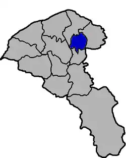
Taoyuan District (Chinese: 桃園區; pinyin: Táoyuán Qū) is a district of Taoyuan City in northwestern Taiwan. Formerly a county-administered city also known as Taoyuan City (桃園市) before 2014, when the former Taoyuan County was elevated to a special municipality which is now known as Taoyuan City. The municipal seat of Taoyuan City is situated within the district. It is the most populous district among the 13 districts of Taoyuan City, and the second most populous among the districts of Taiwan, with the most populous being Banqiao District in New Taipei City.
History


Taoyuan is the native home of the plains tribes of Taiwanese aborigines. Taoyuan's old name was Toahong[1] (Chinese: 桃仔園; pinyin: Táozǐyuán; Pe̍h-ōe-jī: Thô-á-hn̂g; lit. 'peach orchard') since there used to be many peach blossoms in the area.
Empire of Japan
Under Japanese rule, the area was part of Toshien Chō (桃仔園廳) established in November 1901. In 1920, it was renamed Tōen Town (桃園街), and incorporated into Tōen District, Shinchiku Prefecture.
Republic of China
After the handover of Taiwan from Japan to the Republic of China, it was reorganized as Taoyuan Town of Taoyuan County. On 21 April 1971, the town was upgraded from an urban township to a county-administered city called Taoyuan City.[2] On 25 December 2014, the city became a district of the newly formed special municipality of Taoyuan City.
Geography
Taoyuan is located on the Taoyuan Plateau, contiguous on the northeast to Guishan District. The Nankan River is Taoyuan's largest river, flowing from the southeast to the northwest.
- Area: 34.80 km2 (13.44 sq mi)
- Elevation: 157 ft (48 m)
- Population: 464,480 people (February 2023)
Climate
Taoyuan has a humid subtropical climate (Köppen climate classification: Cfa), with hot summers and mild winters. Precipitation is high throughout the year and is generally higher in the first half of the year. Due to the effect of wind from mainland China, Taoyuan is typically cooler than New Taipei, despite having a lower latitude.
Administrative divisions

Dalin, Dafeng, Jianguo, Yunlin, Fuan, Fulin, Fenglin, Zhonghe, Zhongxing, Wenhua, Wenchang, Wenming, Beimen, Minsheng, Yongxing, Guangxing, Ximen, Xihu, Wuling, Zhangmei, Nanmen, Nanhua, Zhongshan, Zhongping, Zhongzheng, Zhongcheng, Zhongxin, Zhongyuan, Zhongtai, Zhongsheng, Zhonglu, Zhongde, Wenzhong, Yushan, Taishan, Longshan, Longan, Longgang, Longxiang, Longshou, Longfeng, Zhongpu, Zhongning, Beipu, Yongan, Tongan, Tongde, Zijiang, Xipu, Mingde, Tungpu, Zhangan, Zhangde, Xinguang, Nanpu, Zhuangjing, Ciwen, Xinpu, Ruiqing, Bao'an, Baoqing, Sanyuan, Sanmin, Dayou, Daxing, Chenggong, Bianzhou, Zhongyi, Tungshan, Tungmen, Jingxi, Chunri, Zhaoyang, Guiji, Wanshou and Baoshan Village.
Government institutions
Education
Within Taoyuan, there are 6 senior high schools, 14 junior high schools, 23 primary schools, and an "intelligence initiation school." Taoyuan is also home to a number of buxibans, or cram schools or language schools, which teach additional courses in mathematics, English, science, etc. There are also 10 universities located in Taoyuan.
Taoyuan Main Public Library is the central library of Taoyuan city. It is located in Xianfu Rd, Taoyuan District, near the Taoyuan City Government building.
Economy
Taoyuan was one of the host cities for the Taiwan European Film Festival in 2012.[3]
Transportation
Taoyuan District is served by Taiwan Railway Administration's Taoyuan railway station. The current station is expected to be converted to an underground station in 2029. In addition, the future underground Zhonglu railway station is also expected to serve the district in 2030. Taoyuan Metro's Green line is also under construction and will serve the district in the future.
Railway
- Taoyuan railway station
- Zhonglu railway station (under construction)
Metro
- Nankan Bus Station (2026)
- Taoyuan Performance Arts Center metro station (2026)
- Daxing West Road metro station (2027)
- Minguang Road metro station (2027)
- Yonghe Market metro station (2027)
- Taoyuan Main Station (2027)
- Yangming Park metro station (2027)
Bus
- San Chung Bus Company
- Taoyuan Bus Company
- United Highway Bus Company
- Zhinan Bus Company
- Zhongli Bus Company
International relations
Twin towns – Sister cities
Taoyuan is twinned with:
 Radom, Poland[4]
 Irvine, California, United States[5]
 Kennewick, Washington, United States
Tourist attractions
- Chaoyang Forest Park
- Chinese Furniture Museum
- Coca-Cola Museum
- Daguixi Park
- Dayou Ecological Park
- Fenghe Park
- Guixi Riverside Park
- Hutou Mountain Park
- Hutoushan Environmental Park
- Sanmin Sports Park
- Taoyuan Arts Center
- Taoyuan Arts Plaza (桃園藝文廣場)
- Taoyuan Confucian Temple
- Taoyuan Land God Culture Museum (桃園市土地公文化館)
- Taoyuan Martyrs' Shrine
- Taoyuan Jingfu Temple
- Taoyuan Night Market
- Tong'an Parent-Child Park
- Yangming Sports Park
Notable natives
- Wu Ming-yi, artist and author
References
- ↑ Davidson, James W. (1903). The Island of Formosa, Past and Present : history, people, resources, and commercial prospects : tea, camphor, sugar, gold, coal, sulphur, economical plants, and other productions. London and New York: Macmillan. p. 597. OCLC 1887893. OL 6931635M.
- ↑ http://www.taocity.gov.tw/en/about.aspx
- ↑ Bartholomew, Ian (November 11, 2012). "European film festival opens". Taipei Times.
- ↑ "Radom - Miasta partnerskie" [Radom - Partnership cities]. Miasto Radom [City of Radom] (in Polish). Archived from the original on April 3, 2013. Retrieved August 7, 2013.
- ↑ "Sister Cities Program". City of Irvine. June 6, 2015. Retrieved September 17, 2018.
- Ginsburg, Norton Sydney; et al. (1991). The Extended metropolis: settlement transition in Asia. University of Hawaii Press. ISBN 9780824812973. Retrieved February 6, 2012.
External links
 Media related to Taoyuan District, Taoyuan at Wikimedia Commons
- Official website
 (in Chinese)