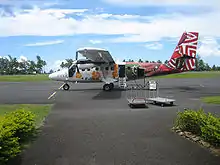
Moorea Airport Aéroport de Moorea Moorea Temae Airport | |||||||||||
|---|---|---|---|---|---|---|---|---|---|---|---|
.JPG.webp) View on approach to Moorea Airport | |||||||||||
| Summary | |||||||||||
| Airport type | Public | ||||||||||
| Operator | SETIL Aéroports | ||||||||||
| Serves | Moorea, French Polynesia, France | ||||||||||
| Elevation AMSL | 16 ft / 5 m | ||||||||||
| Coordinates | 17°29′22″S 149°45′44″W / 17.48944°S 149.76222°W | ||||||||||
| Map | |||||||||||
 MOZ Location of airport in French Polynesia | |||||||||||
| Runways | |||||||||||
| |||||||||||
Moorea Airport (French: Aéroport de Moorea)[2] (IATA: MOZ, ICAO: NTTM) is an airport serving the island of Moorea in French Polynesia, France.[1] It is also known as Temae Airport[4] or Moorea Temae Airport[1] for its location near the village of Temae in northeastern Moorea. The airport is located 7.5 km (4.0 NM) northeast of Afareitu,[1] the island's main village. It is also 15 km (8.1 NM) west of the island of Tahiti.[2] The airport opened on October 6, 1967.[5]
History

- 27 March 1967: Construction of the runway at Moorea‑Temae.
- 6 October 1967: Opening of the Temae airfield.
- 1977: The Moorea-Temae aerodrome is transferred to the SETIL - Société d'Équipement de Tahiti et des Iles (Equipment Company of Tahiti and the Islands).
- 1982: Construction of the existing terminal and adding additional parking spaces.
- 1987: Lengthening the runway to accommodate ATR 42.
- 1990: Construction of a new control tower.
- 2003: Work and upgrading to accommodate ATR 72.
Facilities
The airport resides at an elevation of 16 feet (5 m) above mean sea level. It has one runway designated 12/30 with an asphalt surface measuring 1,237 by 30 metres (4,058 ft × 98 ft).[1]
Airlines and destinations
Passenger
| Airlines | Destinations |
|---|---|
| Air Moana | Bora Bora[6] |
| Air Tahiti | Bora Bora, Huahine-Fare, Papeete, Raiatea |
Ground Transportation
The Moorea Tour Bus comes to the airport to pick up or drop off people. The bus is yellow and green.
Accidents and Incidents
- On August 9, 2007, Air Moorea Flight 1121 crashed shortly after taking off from Temae Airport. The de Havilland Canada DHC-6 Twin Otter was bound for Tahiti's Faa'a International Airport. The report found that the crash was caused by the failure of the pitch control cables following the retraction of the flaps after take-off, which causes significant torque on that aircraft and thus additional pressure on the cables. The failure was caused by significant wear due to the lack of special maintenance and inspections for the stainless-steel cables (which are more subject to wear than their carbon steel counterparts), and exacerbated by the jet-blast of an A340 while the aircraft was parked. Another contributory cause for the crash were found to be the lack of pilot training for loss of pitch control.[7] All 19 passengers and the sole crew member died. Amongst those 19 passengers were two European Union officials.
Annual statistics
Annual statistics for Moorea Airport:[8]
| 2005 | 2006 | 2007 | 2008 | 2009 | |
|---|---|---|---|---|---|
| Passengers | 221,888 | 228,813 | 193,033 | 135,144 | 119,602 |
| Cargo (Tons) | 25 | 30 | 35 | 36 | 32 |
| Aircraft movements | 23,794 | 23 602 | 18,975 | 16,092 | 14,360 |
See also
References
- 1 2 3 4 5 NTTM – Moorea Temae. AIP from French Service d'information aéronautique, effective 28 December 2023.
- 1 2 3 (in French) Aérodrome de Melun Villaroche (LFPM) Archived 2010-03-28 at the Wayback Machine at Union des Aéroports Français
- ↑ Airport information for NTTM[usurped] from DAFIF (effective October 2006)
- 1 2 Airport information for MOZ at Great Circle Mapper. Source: DAFIF (effective October 2006).
- ↑ La SETIL Aéroports exploitant des aéroports: Tahiit Faa'a, Bora Bora, Raiatea, Rangiroa, Huahine, Moorea
- ↑ "Air Moana Moves Marquesas Service Launch to late-March 2023". Aeroroutes. Retrieved 13 December 2022.
- ↑ "Report Accident on 9 August 2007 off the coast of Moorea" (PDF).
- ↑ "Statistiques annuelles: Aéroport de Moorea" (in French). Union des Aéroports Français. Archived from the original on 11 March 2010. Retrieved 21 March 2010.