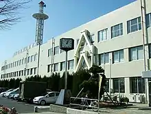
Tenpaku
天白区 | |
|---|---|
| Tenpaku Ward | |
 | |
 Location of Tempaku-ku in Nagoya | |
 Tenpaku | |
| Coordinates: 35°07′21.9″N 136°58′30.4″E / 35.122750°N 136.975111°E | |
| Country | Japan |
| Region | Tōkai region Chūbu region |
| Prefecture | Aichi |
| Area | |
| • Total | 21.58 km2 (8.33 sq mi) |
| Population (October 1, 2019) | |
| • Total | 164,522 |
| • Density | 7,600/km2 (20,000/sq mi) |
| Time zone | UTC+9 (Japan Standard Time) |
| - Flower | Marguerite daisy[1] |
| - Tree | Osmanthus fragrans |
| Phone number | 052-803-1111 |
| Address | 2-201 Shimada, Tempaku-ku, Nagoya-shi, Aichi-ken 468-8510 |
| Website | Official website (in Japanese) |

Tenpaku (天白区, Tenpaku-ku) is one of the 16 wards of the city of Nagoya in Aichi Prefecture, Japan. As of 1 October 2019, the ward had an estimated population of 164,522, and a population density of 7,624 persons per km². The total area was 21.58 square kilometres (8.33 sq mi).
Geography
Tempaku Ward is located in eastern Nagoya city.
Surrounding municipalities
History
The area of present Tempaku District has strong connections with the Oda clan and was a frequently battlefield in the Sengoku period. During the Edo period, it was largely part of Owari Domain under the Tokugawa shogunate. The modern village of Tempaku was established in 1906 within Aichi District. It was annexed by the city of Nagoya in 1955, becoming part of Showa District. In 1975, Showa District was divided into the new Showa District and Tempaku District.
Education
- Meijo University
- Tokai Gakuen University – Nagoya campus
- Toyota Technological Institute
- Nagoya Women's University – Tempaku campus, which was closed in 2015 and integrated into Shioji Campus at Mizuho-ku (See Nagoya Women's University#History [:ja:]).
- Tempaku Ward has one elementary, two middle and three high schools.
Transportation
Railway
Highways
Local attractions
References
- ↑ 天白区のシンボルマークと木と花 (in Japanese). Nagoya City. 1 October 2007.
- ↑ Harina Shrine (針名神社)
- ↑ SOTOZEN Navi
External links
![]() Media related to Tenpaku-ku, Nagoya at Wikimedia Commons
Media related to Tenpaku-ku, Nagoya at Wikimedia Commons