| Thorneside Redland City, Queensland | |||||||||||||||
|---|---|---|---|---|---|---|---|---|---|---|---|---|---|---|---|
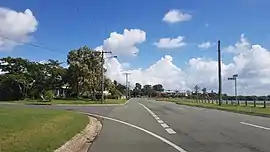
 Queens Esplanade, 2018 | |||||||||||||||
 Thorneside | |||||||||||||||
| Coordinates | 27°29′14″S 153°11′58″E / 27.4872°S 153.1994°E | ||||||||||||||
| Population | 3,761 (2016 census)[1] | ||||||||||||||
| • Density | 1,175/km2 (3,040/sq mi) | ||||||||||||||
| Postcode(s) | 4158 | ||||||||||||||
| Area | 3.2 km2 (1.2 sq mi) | ||||||||||||||
| Time zone | AEST (UTC+10:00) | ||||||||||||||
| LGA(s) | Redland City | ||||||||||||||
| State electorate(s) | Capalaba | ||||||||||||||
| Federal division(s) | Bowman | ||||||||||||||
| |||||||||||||||
Thorneside is a coastal urban locality in the City of Redland, Queensland, Australia.[2] In the 2016 census, Thorneside had a population of 3,761 people.[1]
Geography
The locality is bounded to the north-east by Waterloo Bay (27°28′33″S 153°13′20″E / 27.4759°S 153.2221°E), a part of Moreton Bay.[3] It is bounded to the west by Tingalpa Creek.[4] Mooroondu Point is the northernmost part of the locality at the mouth of the creek, jutting into the bay (27°28′23″S 153°12′05″E / 27.4730°S 153.2015°E)[5][6]
The Cleveland railway line enters the locality from the west (Ransome) and exits to the south-east (Birkdale) with the locality served by Thorneside railway station (27°29′10″S 153°11′34″E / 27.4860°S 153.1928°E).[7][4]
Residential development in the suburb is predominately housing estates built around Thorneside Road and Mooroondu Road.
History
The locality is named after the Thorneside railway station, originally named Thorne's siding after William Thorne who bought a lot of land around Thorneside when it was originally subdivided in 1913. At that time the land was known as Thorne's estate.[8][9]
Demographics
In the 2011 census, Thorneside recorded a population of 3,548 people, 50.1% female and 49.9% male.[10] The median age of the Thorneside population was 38 years, 1 year above the national median of 37. 74.2% of people living in Thorneside were born in Australia. The other top responses for country of birth were New Zealand 6.4%, England 5.7%, Scotland 0.8%, South Africa 0.7%, Ireland 0.7%. 90.6% of people spoke only English at home; the next most common languages were 0.4% Spanish, 0.3% Punjabi, 0.3% Russian, 0.3% French, 0.3% Japanese.[10]
In the 2016 census, Thorneside had a population of 3,761 people.[1]
Amenities
Thorneside Community Hall is at 200-204 Mooroondu Road; it is operated by the Redland City Council.[11]
The Redland City Council operates a mobile library service which visits Beth Boyd Park and Thorneside Community Hall.[12]
There is a boat ramp on the corner of Queens Esplanade and Helen Street on the south bank of Tingalpa Creek (27°28′42″S 153°11′53″E / 27.4784°S 153.1980°E). It is managed by the Redland City Council.[13]
Parks
There are a number of parks in the area:
- Beth Boyd Park, 76-92 Mooroondu Road[14]
- Ferry Road Park (27°29′04″S 153°11′39″E / 27.4845°S 153.1941°E)[15]
- Frank Street Park (27°29′24″S 153°12′20″E / 27.4901°S 153.2056°E)[15]
- John Street Park (27°28′46″S 153°12′10″E / 27.4795°S 153.2028°E)[15]
- Railway Parade Park (27°29′03″S 153°11′30″E / 27.4842°S 153.1918°E)[15]
- William Taylor Memorial Sportsfield (27°29′08″S 153°12′19″E / 27.4855°S 153.2054°E)[15][16]
William Taylor Memorial Sportsfield (also known as Mooroondu Sports field has facilities for soccer, netball, cricket, and tennis.[16]
Other amenities
Other amenities include:
- Willard Webber Reserve
- Queens Esplanade
- Canoe Club Located beside Tingalpa Creek
References
- 1 2 3 Australian Bureau of Statistics (27 June 2017). "Thorneside (SSC)". 2016 Census QuickStats. Retrieved 20 October 2018.
- ↑ "Thorneside – locality in City of Redland (entry 43636)". Queensland Place Names. Queensland Government. Retrieved 30 November 2019.
- ↑ "Bays - Queensland". Queensland Open Data. Queensland Government. 12 November 2020. Archived from the original on 25 November 2020. Retrieved 25 November 2020.
- 1 2 "Queensland Globe". State of Queensland. Retrieved 23 May 2022.
- ↑ "Mountain peaks and capes - Queensland". Queensland Open Data. Queensland Government. 12 November 2020. Archived from the original on 25 November 2020. Retrieved 25 November 2020.
- ↑ "Mooroondu Point – mountain in Redland City (entry 22750)". Queensland Place Names. Queensland Government. Retrieved 25 November 2020.
- ↑ "Railway stations and sidings - Queensland". Queensland Open Data. Queensland Government. 2 October 2020. Archived from the original on 5 October 2020. Retrieved 5 October 2020.
- ↑ "Thorneside (entry 43636)". Queensland Place Names. Queensland Government. Retrieved 17 September 2015.
- ↑ "Birkdale and Thorneside". www.redland.qld.gov.au. Archived from the original on 24 September 2015. Retrieved 17 September 2015.
- 1 2 Australian Bureau of Statistics (31 October 2012). "Thorneside (State Suburb)". 2011 Census QuickStats. Retrieved 10 November 2014.
- ↑ "Thorneside Community Hall". Redland City Council. Archived from the original on 3 March 2022. Retrieved 23 May 2022.
- ↑ "Mobile Library". Redland City Council. Archived from the original on 30 January 2018. Retrieved 31 January 2018.
- ↑ "Recreational Boating Facilities Queensland". Queensland Open Data. Queensland Government. 12 November 2020. Archived from the original on 22 November 2020. Retrieved 22 November 2020.
- ↑ "Beth Boyd Park". Redland City Council. Archived from the original on 23 March 2021. Retrieved 23 May 2022.
- 1 2 3 4 5 "Land for public recreation - Queensland". Queensland Open Data. Queensland Government. 20 November 2020. Archived from the original on 22 November 2020. Retrieved 22 November 2020.
- 1 2 "William Taylor Memorial Sportsfield". Redland City Council. Archived from the original on 3 March 2022. Retrieved 23 May 2022.
External links
- "Thorneside". Queensland Places. Centre for the Government of Queensland, University of Queensland.