Tlachichila | |
|---|---|
Town | |
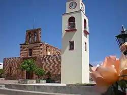
 Saint Augustinus church in Tlachichila | |
| Nickname: Tlachis | |
 Tlachichila Location of Tlachichila within Mexico | |
| Coordinates: 21°33′30″N 102°47′00″W / 21.55833°N 102.78333°W | |
| Country | Mexico |
| State | Zacatecas |
| Municipality | Nochistlán de Mejía |
| largest city | Nochistlan |
| Elevation | 2,220 m (7,280 ft) |
| Population | |
| • Total | 1,554 |
| Time zone | UTC−06:00 (central time) |
| • Summer (DST) | UTC−05:00 (central time) |
| postal/zip code | 99918 |
| Area code | 346-787 |
| ISO 3166 code | MEX |
| Website | www |
Tlachichila is a small town located in the municipality of Nochistlán de Mejía in the Mexican state of Zacatecas. Mexican Federal Highway 131 runs through it.
This article is issued from Wikipedia. The text is licensed under Creative Commons - Attribution - Sharealike. Additional terms may apply for the media files.