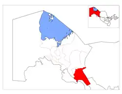
Toʻrtkoʻl District | |
|---|---|
 | |
| Country | |
| Autonomous Republic | Karakalpakstan |
| Capital | Toʻrtkoʻl |
| Area | |
| • Total | 7,480 km2 (2,890 sq mi) |
| Population (2022) | |
| • Total | 221,000 |
| • Density | 30/km2 (77/sq mi) |
| Time zone | UTC+5 (UZT) |
Toʻrtkoʻl District (Uzbek: Тўрткўл, тумани, Toʻrtkoʻl tumani, Karakalpak: Төрткүл райони, Tórtkúl rayonı) is a district of Karakalpakstan in Uzbekistan. The capital lies at the city Toʻrtkoʻl.[1] Its area is 7,480 km2 (2,890 sq mi)[2] and it had 221,000 inhabitants in 2022.[3]
The district contains one city (Toʻrtkoʻl), five towns (Miskin, Turkmankuli, Tozabog, Nurli yoʻl and Amirobod) and 15 rural communities (A. Durdiyev, Jonboshqala, Kana Turtkul, Kaltaminor, Koʻkcha, Ata‘uba, Oʻzbekiston, Oqboshli, Oqqamish, Paxtaabad, Paxtachi, Tazabogʻyap, Ullubogʻ, Shoʻraxon, Qumboskan).[1]
References
- 1 2 "Classification system of territorial units of the Republic of Uzbekistan" (in Uzbek and Russian). The State Committee of the Republic of Uzbekistan on statistics. July 2020.
- ↑ "Qoraqalpog'iston Respublikasining ma'muriy-hududiy bo'linishi" [Administrative-territorial division of the Republic of Karakalpakstan] (PDF) (in Uzbek). Karakalpakstan Republic department of statistics.
- ↑ "Hududlar bo'yicha shahar va qishloq aholisi soni" [Urban and rural population by district] (PDF) (in Uzbek). Karakalpakstan Republic department of statistics.
41°33′N 61°00′E / 41.550°N 61.000°E
This article is issued from Wikipedia. The text is licensed under Creative Commons - Attribution - Sharealike. Additional terms may apply for the media files.
