Trügleben | |
|---|---|
Location of Trügleben | |
 Trügleben 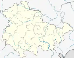 Trügleben | |
| Coordinates: 50°57′2″N 10°37′52″E / 50.95056°N 10.63111°E | |
| Country | Germany |
| State | Thuringia |
| District | Gotha |
| Municipality | Hörsel |
| Area | |
| • Total | 6.07 km2 (2.34 sq mi) |
| Elevation | 350 m (1,150 ft) |
| Population (2010-12-31) | |
| • Total | 363 |
| • Density | 60/km2 (150/sq mi) |
| Time zone | UTC+01:00 (CET) |
| • Summer (DST) | UTC+02:00 (CEST) |
| Postal codes | 99880 |
| Dialling codes | 03621 |
| Vehicle registration | GTH |
Trügleben is a village and a former municipality in the district of Gotha in Thuringia, Germany. Since 1 December 2011, it is part of the municipality Hörsel.
History
Within the German Empire (1871–1918), Trügleben was part of Saxe-Coburg and Gotha.
References
This article is issued from Wikipedia. The text is licensed under Creative Commons - Attribution - Sharealike. Additional terms may apply for the media files.