Trento-Mattarello (G.Caproni) Airport Aeroporto di Trento-Mattarello | |||||||||||
|---|---|---|---|---|---|---|---|---|---|---|---|
 | |||||||||||
| Summary | |||||||||||
| Airport type | Public | ||||||||||
| Operator | Trentino Trasporti | ||||||||||
| Serves | Trento | ||||||||||
| Location | Trento, Italy | ||||||||||
| Elevation AMSL | 610 ft / 186 m | ||||||||||
| Coordinates | 46°01′24″N 011°07′30″E / 46.02333°N 11.12500°E | ||||||||||
| Website | |||||||||||
| Map | |||||||||||
 LIDT Location in Italy | |||||||||||
| Runways | |||||||||||
| |||||||||||
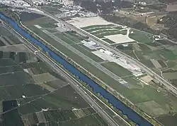
Trento-Mattarello Airport (Italian: Aeroporto di Trento-Mattarello; ICAO: LIDT),[2] also known as Aeroporto G.Caproni, is an airfield located at Trentino, 3.4 NM (6.3 km; 3.9 mi) south [1] of Trento, Italy.
The airport is at an elevation of 610 feet (186 m) above mean sea level. It has one runway designated 18/36 with an asphalt surface measuring 1,130 by 30 metres (3,707 ft × 98 ft).[1]
Facilities
There is an airport hotel on site Fly Bike Hotel, along with a Bar-Restaurant.[3][4]
Operations
The airport is home to numerous flying schools and clubs.[5] Additionally, the Protezione Civile has a fleet of helicopters stationed at the airport.[6]
Transportation
Bus
There is no direct bus service to the airport; however, within a 20-minute walk from the airport terminal (1.5km), Parcheggio Via Lidorno offers a bus service into town?[7]
Car
The airport is nestled between the SS12 and A22 roads, the latter of which connects Trento with the cities of Verona and Bolzano. Access to the airport is quick and easy from both roads.
References
- 1 2 3 "Data" (PDF). www.trentinotrasporti.it. Retrieved 2020-06-17.
- ↑ "✈ Trento / Mattarello Airport (ZIA/LIDT) in Italien | Abflug.info". www.abflug.info. Retrieved 2022-03-09.
- ↑ "FLY BIKE HOTEL $68 ($̶7̶5̶) - Prices & Reviews - Trento, Italy". Tripadvisor.
- ↑ "Servizi". www.trentinotrasporti.it.
- ↑ "Aziende in aeroporto". www.trentinotrasporti.it.
- ↑ "RCStudio - Airport Trento-Mattarello - LIDT". Aerosoft Shop (in German). Retrieved 2022-03-09.
- ↑ "Navetta parcheggi". www.trentinotrasporti.it.