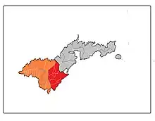
Tuālāuta County is a county in the Western District in American Samoa.[1][2][3] It is the largest and also the most populated county in American Samoa. The county is represented by two seats in the Senate and two seats in House of Representatives in the American Samoa Legislature.[4] 'Ili'ili is the principal place in Tualauta County, a county which consists of 'Ili'ili, Pava'ia'i, Mapusaga, Faleniu, Mesepa, Malae'imi, Tafuna, and Vaitogi.[5]
As of 2015, the county has a population of 19,519 residents.[6] Tualauta County has the highest number of registered voters in American Samoa: 2,033 female voters and 1,660 male voters (3,693 total voters). However, in terms of votes cast in the 2016 election, more votes were cast in Maoputasi County. Tualauta County also has the highest number of voters between the ages of 18 and 35 with 2,105.[7]
Tualauta County, which is the most populated county in American Samoa, had the highest number of housing units according to the 2010 U.S. census with 4,080 units, followed by 1,999 housing units for Maoputasi County.[8] Tualauta County has experienced a large population increase and, as of the 2010 U.S. census, the county had over double the number of residents as Maoputasi County (home to the territorial capital of Pago Pago).[9]
At 9.91 square miles (25.7 km2), it is the largest county in American Samoa.[10]
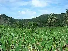
Tuālāuta contains most of Tutuila Island's flatland, including the Tafuna Plain.[11]
Demographics
| Year | Pop. | ±% |
|---|---|---|
| 1912 | 574 | — |
| 1920 | 651 | +13.4% |
| 1930 | 812 | +24.7% |
| 1940 | 944 | +16.3% |
| 1950 | 1,838 | +94.7% |
| 1960 | 2,141 | +16.5% |
| 1970 | 3,671 | +71.5% |
| 1980 | 6,855 | +86.7% |
| 1990 | 14,724 | +114.8% |
| 2000 | 22,025 | +49.6% |
| 2010 | 20,858 | −5.3% |
| U.S. Decennial Census[12] | ||
Tuālāuta County was first recorded beginning with the 1912 special census. Regular decennial censuses were taken beginning in 1920.[13]
Villages
Landmarks
- American Samoa Community College, in Mapusaga
- Cathedral of the Holy Family, in Tāfuna
- Fogāma'a Crater National Natural Landmark, in Vaitogi
- 'Ili'ili Golf Course, in 'Ili'ili
- Lions Park, in Tāfuna
- Pago Pago International Airport, in Tāfuna
- Tradewinds Hotel, at Ottoville
- Turtle and Shark site, in Vaitogi
- Tia Seu Lupe historical site, at Fatuoaiga
- Tony Solaita Baseball Field, in Tāfuna
- Veterans Memorial Stadium, in Tāfuna
References
- ↑ "CPH-T-8. Population, Housing Units, Land Area, and Density for U.S. Island Areas: 2010" (PDF). United States Census. Retrieved 4 February 2019.
- ↑ 1987 Census of Agriculture: Geographic area series, Parts 55-56. Bureau of the Census. 1991. p. 4.
- ↑ "5.0102 Division of districts into counties". www.asbar.org.
- ↑ Fai’ivae, Alex Godinet (2018). Ole Manuō o Tala Tu’u Ma Fisaga o Tala Ave. Amerika Samoa Humanities Council. Page 120. ISBN 9781546229070.
- ↑ Krämer, Augustin (2000). The Samoa Islands. University of Hawaii Press. Page 448. ISBN 9780824822194.
- ↑ "Taulauta faipule Vui seeks to amend Constitution to add two more seats for her district". 7 April 2017.
- ↑ "Election Office stats show registered female voters outnumber male voters". 4 May 2017.
- ↑ "2010 census reveals jump in local housing units". 20 February 2012.
- ↑ "Lawmakers hear 'options' on the House reapportionment issue". 4 April 2018.
- ↑ "Territory of American Samoa: MULTI-HAZARD MITIGATION PLAN" (PDF). American Samoa Governor’s Office. April 2015. p. 141. Retrieved 5 July 2022.
- ↑ Hills, J.W. (2022). O Upu Muamua I Le Tala I Le Lalolagi Mo E Ua Faatoa A'oa'oina U Lea Mataupu. Legare Street Press. Page 61. ISBN 9781019136812.
- ↑ "U.S. Decennial Census". Census.gov. Retrieved June 6, 2013.
- ↑ "1920 Census: Outlying Possessions" (PDF). US Census Bureau. p. 1231. Retrieved 5 July 2022.
14°21′6″S 170°44′49″W / 14.35167°S 170.74694°W