Udaipur | |
|---|---|
town | |
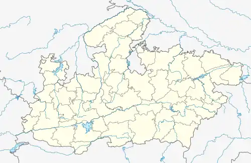 Udaipur Location in Madhya Pradesh, India | |
| Coordinates: 23°54′01″N 78°03′24″E / 23.900177°N 78.056655°E | |
| Country | |
| State | Madhya Pradesh |
| District | Vidisha |
| Languages | |
| • Official | Hindi |
| Time zone | UTC+5:30 (IST) |
| PIN | 464221 |
| Telephone code | 91-7594 |
| Vehicle registration | MP-40 |
Udaipur is a town in the Indian state of Madhya Pradesh near Ganj Basoda. It is the site of a well-preserved Śiva temple, a monument of national importance protected by the Archaeological Survey of India.
History
Udaipur's history reaches back to at least the ninth century, but it became famous and appears to have assumed its present name under the Paramāra king Udayāditya (c. 1060-87).[1] It continued to be important in the 14th, 15th and 16th centuries, and was an important town on the north-south trade route.
Geography
Udaipur is located at 23°54'2"N 78°3'29"E.
Transport
Udaipur is connected by bus service from Ganj Basoda railway station 93 km from Bhopal Junction towards Jhansi (203 km) and 604 km from New Delhi Jn.
Monuments

The monuments of Udaipur were first studied by M. B. Garde and published in the reports of the archaeological department of Gwalior state. The data in these reports was compiled into a list prepared in 1952.[2]
Śiva temple, 1080 CE
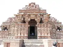
The most important temple at Udaipur is that dedicated to Śiva and known today as the Nīlakaṇṭheśvara. It is a Protected Monument of national importance under the Archaeological Survey of India, number N-MP-289 in the List of Monuments of National Importance in Madhya Pradesh/East. The temple was built in the second half of the eleventh century and is the only surviving royal temple of the Paramara kings. An inscription in the eastern porch records the building of the temple in Vikrama Saṃvat 1137 or 1080-81 CE.[3]

Inscriptions
In addition to the dedicatory inscription, entrance porch of the temple has a series of more than sixty votive records.[4] Not yet studied in a systematic fashion, these form a continuous sequence from the time of the Paramāras – Devapāla (1218–39) is mentioned – through the period of the Tughluqs and beyond. For example, one inscription mentions a festival (yātrā) of the god Udaleśvara in 1338, the same year as the Tughluq inscription recording the construction of the mosque in the temple precinct.[5]
Architecture
Architecturally, the temple spire belongs to a class known as bhūmija, or 'earth born,' a mode of temple building that originated in the Mālwa region.[6]
Iconography
The complex Śaiva iconography of the temple has been studied by Doria Tichit.[7]
Tughluq Shahi mosque, 1338-39 CE

Directly next to the temple is a small mosque constructed during the reign of Muhammad ibn Tughluq. A pair of inscriptions record the building of this structure in 739 AH (i.e. 1338-39 CE).[8]
Islam Shah Suri mosque, 1549 CE
A short distance to the south of the Shiva temple is a mosque with an inscription recording its construction in the time of Islam Shah of the Sur Dynasty in 1549.[9] The inscription is placed directly over the mihrab.[10] The shows the continued importance of Udaypur on the north-south route to the Deccan in the time of the Suri rulers.
Shahi Mahal and Shahi Masjid, 1617–32 CE
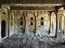
Directly east of Nīlakaṇṭheśvara is a large palace complex known as Shāhī Maḥal, which served as the residence of the local governor during the Mughal rule.[11] Built on a rectangular plan, the maḥal has four corner towers and a two-storey elevation, with a suite of rooms disposed around two interlinked courtyards, all decorated in the simple and elegant stonecarving style of the 17th century. The existing ruins retain traces of excellent stone jālī work. Forming an adjunct of the maḥal is a big mosque, an imposing edifice locally known as Shāhī Masjid or Qāḍiyon-kī-Masjid.[11][12] A Persian inscription carved on a slab measuring 65 x 42 cm, affixed on the central mihrab of the mosque, records its foundation by Qāḍi Awliyā b. Sayyid ʿAbd al-Ṣamad al-Ḥasanī on 4 Rajab 1026 Hijrī, or 28 June 1617 CE, at the time when Emperor Jahāngīr was on a visit to Mandu.[12] A second Persian inscription carved on a slab measuring 4'1" x1', in a balcony projecting from the north wall of the mosque records that the mosque was only half complete when both king and qāḍi passed away, and that it was finally completed by Sayyid Ḥāmid and Sayyid Dāʾūd, sons of Qāḍi Awliyā, on 10 Dhū'l-Ḥijja 1041 Hijrī, or 18th June 1632 CE, during the reign of Emperor Shāhjahān.[13] Both inscriptions show that this mosque served as the main Jama Masjid of Udaypur in the Mughal period and was the seat of the town's state-appointed qāḍi. The epigraphs are also significant for the political geography of the times, showing that qasba Udaypur was then part of sarkar Chanderi and suba Malwa, on the border of Gondwana.[13]
References
- ↑ Arvind K. Singh, "Interpreting the History of the Paramāras," Journal of the Royal Asiatic Society 3, 22, 1 (2012), pp. 13–28. Online version: http://journals.cambridge.org/action/displayJournal?jid=JRA
- ↑ D. R. Patil, The Descriptive and Classified List of Archaeological Monuments in Madhya Bharat (Gwalior: Dept. of Archaeology, Madhya Bharat Government, 1952).
- ↑ "Foundation record of the Udayesvara temple". SIDDHAM: the Asia Inscriptions Database. Retrieved 19 February 2020.
- ↑ The records are listed in Annual Report on Indian Epigraphy (1961-62), section C, nos. 1611-1677.
- ↑ Annual Report on Indian Epigraphy (1961-62), section C, no. 1625.
- ↑ Krishna Deva, "Bhumija Temples," in Studies in Indian Temple Architecture, ed. P. Chandra (Delhi: AIIS, 1975): 90-113; Adam Hardy, Theory and Practice of Temple Architecture in Medieval India: Bhoja's Samarānganasūtradhāra and the Bhojpur Line Drawings, with translations by Mattia Salvini (New Delhi: IGNCA, 2015)
- ↑ Doria Tichit, "Le programme iconographique du temple d’Udayeśvara à Udayapur, Madhya Pradesh, XIe siècle," Arts asiatiques 67, no. 1 (2012): 3-18. Available online: http://www.persee.fr/doc/arasi_0004-3958_2012_num_67_1_1770.
- ↑ A. Cunningham, Archaeological Survey of India Reports, vol. 10, p. 68; D. R. Patil, The Descriptive and Classified List of Archaeological Monuments in Madhya Bharat (Gwalior: Dept. of Archaeology, Madhya Bharat Government, 1952): no. 1692; Indian Archaeology: A Review (1983-84), p. 56.
- ↑ Rahim, Syed Abdur (2000). Arabic, Persian and Urdu inscriptions of Central India : a topographical list. New Delhi: Sundeep Prakashan. p. 123.
- ↑ "Udaypur उदयपुर (Madhya Pradesh). Arabic and Persian inscription (INAP00005)". SIDDHAM: the Asia Inscriptions Database. Retrieved 18 February 2020.
- 1 2 Garde, M. B. (1934). Archaeology in Gwalior (2nd ed.). Gwalior: Alijah Darbar Press. pp. 139–140.
- 1 2 Saksena, Ramsingh (1927). "Persian Inscriptions in the Gwalior State". Indian Historical Quarterly. 3 (4): 715–718.
- 1 2 Rahim, S.A. (1969). "Inscriptions of Akbar and Jahangir from Madhya Pradesh". Epigraphia Indica: Arabic and Persian Supplement 1968: 63–65.