Uftrungen | |
|---|---|
Location of Uftrungen | |
 Uftrungen 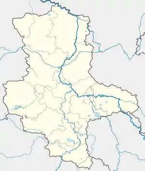 Uftrungen | |
| Coordinates: 51°29′56″N 10°58′47″E / 51.49889°N 10.97972°E | |
| Country | Germany |
| State | Saxony-Anhalt |
| District | Mansfeld-Südharz |
| Municipality | Südharz |
| Area | |
| • Total | 29.65 km2 (11.45 sq mi) |
| Elevation | 221 m (725 ft) |
| Population (2006-12-31) | |
| • Total | 1,108 |
| • Density | 37/km2 (97/sq mi) |
| Time zone | UTC+01:00 (CET) |
| • Summer (DST) | UTC+02:00 (CEST) |
| Postal codes | 06548 |
| Dialling codes | 034653 |
| Vehicle registration | MSH |
| Website | www.rossla.de |
Uftrungen is a village and a former municipality in the Mansfeld-Südharz district, Saxony-Anhalt, Germany. Since 1 January 2010, it is part of the municipality Südharz.
.JPG.webp) The Schluftstraße
The Schluftstraße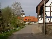 Village centre with church
.JPG.webp) Abandoned area "An der Kirche"
Abandoned area "An der Kirche".JPG.webp) St. Andrews' church (1732–1734)
St. Andrews' church (1732–1734)
This article is issued from Wikipedia. The text is licensed under Creative Commons - Attribution - Sharealike. Additional terms may apply for the media files.