Ventspils Municipality
Ventspils novads | |
|---|---|
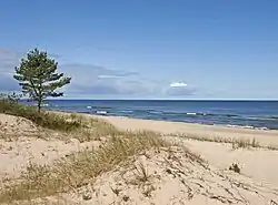 Baltic Sea coast near Miķeļtornis | |
 Flag  Coat of arms | |
 | |
| Country | |
| Formed | 2009 |
| Centre | Ventspils (extraterritorially) |
| Government | |
| • Council Chair | Aivars Mucenieks (LZS) |
| Area | |
| • Total | 2,458.62 km2 (949.28 sq mi) |
| • Land | 2,365.25 km2 (913.23 sq mi) |
| • Water | 93.37 km2 (36.05 sq mi) |
| Population (2023)[2] | |
| • Total | 10,512 |
| • Density | 4.3/km2 (11/sq mi) |
| Website | www |
Ventspils Municipality (Latvian: Ventspils novads) is a municipality in Courland, Latvia. The municipality was formed in 2009 by merging Piltene town, Ance Parish, Jūrkalne Parish, Piltene rural community (from 2010 Piltene Parish), Pope Parish, Puze Parish, Tārgale Parish, Ugāle Parish, Usma Parish, Užava Parish, Vārve Parish, Ziras Parish and Zlēkas Parish. It is administered from Ventspils city, which is not included within its limits. The population in 2020 was 10,824.[3]
See also
References
- ↑ "Reģionu, novadu, pilsētu un pagastu kopējā un sauszemes platība gada sākumā". Central Statistical Bureau of Latvia. Retrieved 18 January 2023.
- ↑ "Iedzīvotāju skaits pēc tautības reģionos, pilsētās, novados, pagastos, apkaimēs un blīvi apdzīvotās teritorijās gada sākumā (pēc administratīvi teritoriālās reformas 2021. gadā) 2021 - 2022". Central Statistical Bureau of Latvia. Retrieved 3 October 2023.
- ↑ "ISG020. Population number and its change by statistical region, city, town, 21 development centres and counties". Central Statistical Bureau of Latvia. 2020-01-01. Retrieved 2021-02-12.
This article is issued from Wikipedia. The text is licensed under Creative Commons - Attribution - Sharealike. Additional terms may apply for the media files.