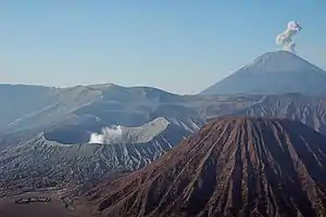
View of Semeru and Bromo eruption with Mount Batok in East Java

The Indonesian island of Java is almost entirely of volcanic origin, and contains numerous volcanoes, 45 of which are considered active volcanoes. As is the case for many other Indonesian islands, volcanoes have played a vital role in the geological and human history of Java. Indeed, land is created on Java as a result of lava flows, ash deposits, and mud flows (lahars). Volcanoes are a major contributor to the immense fertility of Java, as natural erosion transports volcanic material as alluvium to the island's plains, forming thick layers of fertile sediment. The benefit is not just in the immediate vicinity of the volcano, with fine ash emitted from eruptions being dispersed over wide areas.

Climbing volcanoes (and other mountains) is increasingly popular.

List of volcanoes

Mount Merapi (left foreground) and Merbabu (right); with far view of Mount Ungaran, Sumbing, Sundoro, Dieng, and Slamet in Central Java

This list is of volcanoes from the west of Java to the east. Local terminology and usage has the word Gunung (mount or mountain) precede the names.

West Java

Central Java

East Java

List of active volcanoes

Name Shape Elevation Last eruption (VEI) Geolocation
m ft
Pulosaristratovolcano 1,346 4,416 unknown 6°20′31″S 105°58′30″E / 6.342°S 105.975°E / -6.342; 105.975
Gunung Karangstratovolcano 1,778 5,833 unknown 6°16′12″S 106°02′31″E / 6.27°S 106.042°E / -6.27; 106.042
Kiaraberes-Gagakstratovolcano 1,511 4,957 6 Apr 1939 (1) 6°44′S 106°39′E / 6.73°S 106.65°E / -6.73; 106.65
Perbaktistratovolcano 1,699 5,574 unknown 6°45′S 106°41′E / 6.75°S 106.68°E / -6.75; 106.68
Salakstratovolcano 2,211 7,254 31 Jan 1938 (2) 6°43′S 106°44′E / 6.72°S 106.73°E / -6.72; 106.73
Gedestratovolcano 2,958 9,705 13 Mar 1957 (2) 6°47′S 106°59′E / 6.78°S 106.98°E / -6.78; 106.98
Patuhastratovolcano 2,434 7,986 unknown 7°09′36″S 107°24′00″E / 7.160°S 107.40°E / -7.160; 107.40
Wayang-Windulava dome 2,182 7,159 unknown 7°12′29″S 107°37′48″E / 7.208°S 107.63°E / -7.208; 107.63
Malabarstratovolcano 2,343 7,687 unknown 7°08′S 107°39′E / 7.13°S 107.65°E / -7.13; 107.65
Tangkuban Perahustratovolcano 2,084 6,837 26 Jul 2019 (1) 6°46′S 107°36′E / 6.77°S 107.60°E / -6.77; 107.60
Papandayanstratovolcano 2,665 8,743 11 Nov 2002 (2) 7°19′S 107°44′E / 7.32°S 107.73°E / -7.32; 107.73
Kendangstratovolcano 2,608 8,556 unknown 7°14′S 107°43′E / 7.23°S 107.72°E / -7.23; 107.72
Kamojangstratovolcano 1,730 5,680 Pleistocene 7°07′30″S 107°48′00″E / 7.125°S 107.80°E / -7.125; 107.80
Gunturcomplex volcano 2,249 7,379 16 Oct 1847 (2) 7°08′35″S 107°50′24″E / 7.143°S 107.840°E / -7.143; 107.840
Tampomasstratovolcano 1,684 5,525 unknown 6°46′S 107°57′E / 6.77°S 107.95°E / -6.77; 107.95
Galunggungstratovolcano 2,168 7,113 9 Jan 1984 (1) 7°15′00″S 108°03′29″E / 7.25°S 108.058°E / -7.25; 108.058
Talagabodasstratovolcano 2,201 7,221 unknown 7°12′29″S 108°04′12″E / 7.208°S 108.07°E / -7.208; 108.07
Karahafumarole 1,155 3,789 unknown 7°07′S 108°05′E / 7.12°S 108.08°E / -7.12; 108.08
Ceremestratovolcano 3,078 10,098 1951 6°53′31″S 108°24′00″E / 6.892°S 108.40°E / -6.892; 108.40
Slametstratovolcano 3,432 11,260 1 May 1999 (1) 7°14′31″S 109°12′29″E / 7.242°S 109.208°E / -7.242; 109.208
Diengcomplex volcano 2,565 8,415 31 Dec 1996 (1) 7°12′S 109°55′E / 7.20°S 109.92°E / -7.20; 109.92
Sundorostratovolcano 3,136 10,289 29 Oct 1971 (2) 7°18′00″S 109°59′31″E / 7.30°S 109.992°E / -7.30; 109.992
Sumbingstratovolcano 3,371 11,060 1730 (1) 7°23′02″S 110°04′12″E / 7.384°S 110.070°E / -7.384; 110.070
Ungaranstratovolcano 2,050 6,730 unknown 7°11′S 110°20′E / 7.18°S 110.33°E / -7.18; 110.33
Telomoyostratovolcano 1,894 6,214 unknown 7°22′S 110°24′E / 7.37°S 110.40°E / -7.37; 110.40
Merbabustratovolcano 3,145 10,318 1797 (2) 7°27′S 110°26′E / 7.45°S 110.43°E / -7.45; 110.43
Merapistratovolcano 2,968 9,738 28 Mar 2020 (3) 7°32′31″S 110°26′31″E / 7.542°S 110.442°E / -7.542; 110.442
Muriastratovolcano 1,625 5,331 160 ± 30 years 6°37′S 110°53′E / 6.62°S 110.88°E / -6.62; 110.88
Lawustratovolcano 3,265 10,712 28 Nov 1885 (1) 7°37′30″S 111°11′31″E / 7.625°S 111.192°E / -7.625; 111.192
Wilisstratovolcano 2,563 8,409 unknown 7°48′29″S 111°45′29″E / 7.808°S 111.758°E / -7.808; 111.758
Keludstratovolcano 1,731 5,679 13 Feb 2014 (4) 7°55′48″S 112°18′29″E / 7.93°S 112.308°E / -7.93; 112.308
Kawi-Butakstratovolcano 2,651 8,698 unknown 7°55′S 112°27′E / 7.92°S 112.45°E / -7.92; 112.45
Arjuno-Welirangstratovolcano 3,339 10,955 15 Aug 1952 (0) 7°43′30″S 112°34′48″E / 7.725°S 112.58°E / -7.725; 112.58
Penanggunganstratovolcano 1,653 5,423 unknown 7°37′S 112°38′E / 7.62°S 112.63°E / -7.62; 112.63
Malang Plainmaar 680 2,230 unknown 8°01′S 112°41′E / 8.02°S 112.68°E / -8.02; 112.68
Semerustratovolcano 3,676 12,060 19672021 continuing (3) 8°06′29″S 112°55′12″E / 8.108°S 112.92°E / -8.108; 112.92
Tenggerstratovolcano 2,329 7,641 8 Jun 2004 (2) 7°56′31″S 112°57′00″E / 7.942°S 112.95°E / -7.942; 112.95
Lamonganstratovolcano 1,651 5,417 5 Feb 1898 (2) 7°58′44″S 113°20′31″E / 7.979°S 113.342°E / -7.979; 113.342
Luruscomplex volcano 539 1,768 unknown 7°44′S 113°35′E / 7.73°S 113.58°E / -7.73; 113.58
Iyang-Argapuracomplex volcano 3,088 10,131 unknown 7°58′S 113°34′E / 7.97°S 113.57°E / -7.97; 113.57
Raungstratovolcano 3,332 10,932 3 Oct 2020 (1) 8°07′30″S 114°02′31″E / 8.125°S 114.042°E / -8.125; 114.042
Ijenstratovolcano 2,799 9,183 28 Jun 1999 (1) 8°03′29″S 114°14′31″E / 8.058°S 114.242°E / -8.058; 114.242
Baluranstratovolcano 1,247 4,091 unknown 7°51′S 114°22′E / 7.85°S 114.37°E / -7.85; 114.37

See also

References

    • Whitten, T, Soaeriaatmadja, R. E., Afiff, S. A., (editors), The Ecology of Java and Bali, Periplus Editions (HK) Ltd. 1996, Hardcover, 969 pages, ISBN 962-593-072-8
    This article is issued from Wikipedia. The text is licensed under Creative Commons - Attribution - Sharealike. Additional terms may apply for the media files.