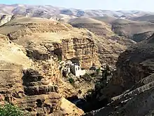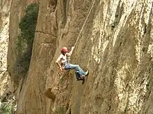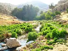


Wadi Qelt (Arabic: وادي القلط; Qelt is also spelled Qilt and Kelt, sometimes with the Arabic article, el- or al-), in Hebrew Nahal Prat (Hebrew: נחל פרת), formerly Naḥal Faran (Pharan brook), is a valley, riverine gulch or stream (Arabic: وادي wādī, "wadi"; Hebrew: נחל, "nahal") in the West Bank, originating near Jerusalem and running into the Jordan River near Jericho, shortly before it flows into the Dead Sea.
The wadi attracts with a number of natural, biblical, and archaeological highlights: a well preserved natural environment with a rich wild bird population.
Geography
The stream flowing eastwards down the valley that cuts through the limestone of the Judean Mountains, has three perennial springs, each with an Arabic and Hebrew name: 'Ayn Farah/En Prat, the largest one at the head of the valley; 'Ayn Fawar/En Mabo'a in the centre; and the single-named Qelt spring a little farther down.[1] In Hebrew the entire stream is called Prat; in Arabic though, each sections has its own name: Wadi Fara for the upper section, Wadi Fawar for the middle one, and Wadi Qelt for the lower section.[1]
Environment
Wadi Qelt is home to a unique variety of flora and fauna.
Important Bird Area
The 15,000 ha site has been recognised as an Important Bird Area (IBA) by BirdLife International because it supports populations of Eurasian eagle-owls, griffon vultures, Bonelli's eagles, and lesser kestrels.[2]
Religious relevance
Hebrew Bible
Joshua 15:7, 18:17 mentions Adummim in connection to an ascent leading up from Jericho towards Jerusalem. The ascent of Adummim, or its lower part, is identified with Wadi Qelt.
The stream Chorath or Cherath, mentioned in 1 Kings 17:3 as one of the hiding places of the prophet Elijah, has been identified by some with Wadi Kelt at St. George's Monastery.[3] Other identifications have also been proposed.
The Wadi has sometimes been identified with the biblical Perath mentioned in Jeremiah 13:5.[4]
It's possible that the Psalmist had Wadi Qelt in mind when he wrote Psalm 23.
Christian tradition
A tradition holds that this is the place in the desert where Joachim, the father of the Virgin Mary, has prayed to be blessed with a child and received the promise from God's angel, as narrated in the apocryphal Proto-Gospel of James.[5] A Cave of St Anne, inhabited by hermits until a few decades ago, is connected to this tradition.
St. George's Monastery,[4] also connected to the Marian tradition, is built into the wadi cliffs a short distance upstream from the Cave of St Anne.
History
Bronze Age and Iron Age
Qubur Bani Isra'in are very large Bronze-Age stone structures, which rise from a rocky plateau overlooking Wadi Qelt.[6]
Hellenistic and Roman periods
Several aqueducts have been found along the stream, the oldest dating to the Hasmonean period (2nd century BCE).[1] The aqueducts transported water from three main springs, down to the plain of Jericho.[7]
The winter palaces of Hasmonean kings and Herod the Great stood at the lower end of the valley, where it reaches the Plain of Jericho.[8] A structure within the Hasmonean royal winter palaces, identified by its excavator, Ehud Netzer, as a synagogue, is now known as the Wadi Qelt Synagogue, is believed to be one of the oldest synagogues in the world--[9][10] although its identification as a synagogue is contested by many scholars.
During the First Jewish war with Rome, insurgent leader Simon bar Giora is said to have held out in caves in this valley, known formerly as the Pharan brook.[11]
Late Roman and Byzantine monasticism
Wadi Qelt contains monasteries and old Christian locations.[1] According to tradition, the first monastic settlement of the Judaean desert, the Pharan lavra, was established by St Chariton the Confessor towards the end of the 3rd century in upper Wadi Qelt,[12] an area known to the Greek Orthodox as Pharan Valley.
The Monastery of Saint George was founded by John of Thebes around 480 AD, and it became an important spiritual centre in the sixth century under Saint George of Choziba. Hermits living in caves in nearby cliffs would meet in the monastery for a weekly mass and communal meal.[13]
Another Byzantine monastery was excavated at the site known in Arabic as Khan Saliba.[14] Its meager remains are located left at the left side of the T-junction of the road connecting the modern Highway 1 with the old road down the Ascent of Adummim (going to the right one reaches Jericho in the plain below.)[14] The 5th-century Monastery of St Adam was built there "for there he stayed and wept at losing Paradise" (Epiphanius).[14] Archaeologists found fine Byzantine mosaics at the former pilgrimage site.[15][16]
1948
Towards the end of the 1948 Palestine war and from the outset of the Arab-Israeli war that followed, the springs of Wadi Qelt, which supplied much of the water for Jericho were a primary target for Israel's biological warfare programme, designed, by contaminating waters with typhus and diphtheria bacteria, to block the advance of the Arab Legion into the area which, in the United Nations Partition Plan for Palestine, had been destined for the Arab population. Some evidence suggests that a well-poisoning operation may have unfolded in this area in July of that year.[17]
1967 and after
The area was occupied by Israel in 1967.
On December 20, 1968, Israeli lieutenant-Colonel Zvi (Tzvika) Ofer, commander of the elite Haruv unit, former Military Governor of Nablus and recipient of the Israeli medal of valour, was killed in action in Wadi Qelt while pursuing Arab militants who had crossed the Jordan.[18]
Tourism

Israel declared the upper parts of the wadi as a protected area under the name Ein Prat Nature Reserve.[1]
Much of Wadi Qelt is a popular route for Palestinian and Israeli hikers. It is possible to hike all the way from the town of Hizma to Jericho, a journey of 25 kilometres and an 850m descent.[19]
Israeli, Palestinian and foreign hikers use the partially marked paths along the wadi. Palestinians are generally able to visit when coming from Nablus, Ramallah and Jerusalem without having to pass through checkpoints.
Bedouin
The wadi is used by many Bedouin shepherds. Some Bedouin and residents of Jericho are also earning their livelihood near the Monastery of St George, by offering donkey rides to pilgrims and selling them beverages and souvenirs.[20][21][22]
See also
- Chariton the Confessor, 3rd-century founder of a lavra-type monastery in Pharan Valley (upper Wadi Qelt)
- Jordan Valley
References
- 1 2 3 4 5 "En Prat Nature Reserve". allaboutjerusalem.com.
- ↑ "Wadi Al-Qelt". BirdLife Data Zone. BirdLife International. 2021. Retrieved 25 February 2021.
- ↑ "The Life Of John The Elder And The Cave Of Sapsas". St. Luke the Evangelist Greek Orthodox Church. Retrieved 9 July 2016.
- 1 2 "Wadi Qilt". bibleplaces.com.
- ↑ Choziba and the Fatherhood of Saint Joachim. Antonio Olivan, Marie de Nazareth Association. Retrieved 6 Oct 2021.
- ↑ "The Tombs of the Children of Israel". goisrael.com.
- ↑ Gruber, Angela (3 April 2015). "In the occupied West Bank, even hiking is political". +972 mag. Retrieved 2 March 2016.
- ↑ "Jericho - The Winter Palace of King Herod - Jewish Virtual Library". jewishvirtuallibrary.org.
- ↑ Oldest Synagogue Found in Israel Archived 2015-09-24 at the Wayback Machine, March 29, 1998. Associated Press
- ↑ Israel's Oldest Synagogue, Archaeology, Volume 51 Number 4, July/August 1998, Spencer P.M. Harrington
- ↑ Samuel Klein, The Twenty-four City Councils in Judea (ארבע ועשרים בולאות שביהודה), Vienna 1933, p. 293 (in memory of R. Zvi Peretz Chayot), where he cites Schick and Nestle in Zeitschrift des deutschen Palästina-Vereins (ZDPV – Journal of the German Society for Exploration of Palestine), 1911, pp. 103–ff. Cf. Josephus (Wars 4.9.4).
- ↑ Skete of Saint Chariton - Fara, Russian Orthodox Ecclesiastical Mission in Jerusalem
- ↑ Palestine & Palestinians. Beit Sahour: Alternative Tourism Group. September 2008. p. 181. ISBN 978-9950-319-01-1.
- 1 2 3 Jerome Murphy-O'Connor (2008). The Holy Land: An Oxford Archaeological Guide from Earliest Times to 1700. Oxford Archaeological Guides. Oxford: Oxford University Press. p. 452. ISBN 978-0-19-923666-4. Retrieved 30 July 2019.
- ↑ Michael Dumper; Bruce E. Stanley, eds. (2007). Cities of the Middle East and North Africa: A Historical Encyclopedia. ABC-CLIO. p. 205. ISBN 9781576079195. Retrieved 30 July 2019.
- ↑ Prignaud, Jean (1963). "Une installation monastique byzantine au Khan Ṣaliba". Revue Biblique (1946-). Peeters Publishers. 70 (Vol. 70, No. 2 (April 1963)): 243–254. JSTOR 44091910.
- ↑ Benny Morris, Benjamin Z. Kedar, ‘Cast thy bread’: Israeli biological warfare during the 1948 War Middle Eastern Studies 19 September 2022, pages =1-25 p.6.
- ↑ Teveth, Shabtai (1969/1970) The Cursed Blessing. The story of Israel's occupation of the West Bank. Weidenfeld & Nicolson. SBN 297 00150 7. Translated from Hebrew by Myra Bank. Page 347.
- ↑ Szepesi, Stefan (2012). Walking Palestine: 25 Journeys Into The West Bank. Oxford: Signal. p. 201. ISBN 978-1-908493-61-3.
- ↑ Shem Tov Sasson, University Trip: Wadi Qelt II, Israel's Good Name, 12 February 2018, accessed 3 August 2019
- ↑ Jitka Zich, Wadi Qelt (Kelt) Hike and GuideBook: Monastery of St. George of Choziba, Israel By Foot, accessed 3 August 2019
- ↑ Donkey tours, Hantourism, accessed 3 August 2019
External links
- "En Prat Nature Reserve". Israel Nature and Parks Authority. Retrieved 24 April 2021. The Israeli national park covers the upper part of the valley and is centered on the Ein Fara/En Prat spring; entry fee required.
- Bible Places
- The Way by Jericho
- Hike in Wadi Qelt
- Survey of Western Palestine, Map 18: IAA, Wikimedia commons