| Westgate Hotel | |
|---|---|
Gwesty Porth Gorllewin | |
.jpg.webp) Westgate Hotel from Westgate Square | |
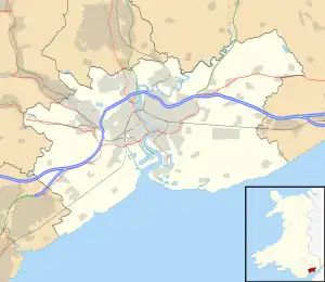
 Location within Newport | |
| General information | |
| Status | Mostly derelict |
| Architectural style | Regency and French Renaissance |
| Classification | Grade II listed |
| Location | Commercial Street, Newport |
| Address | Westgate Buildings, Commercial Street |
| Town or city | Newport |
| Country | Wales |
| Coordinates | 51°35′16″N 2°59′48″W / 51.587814°N 2.996713°W |
| Current tenants | Unoccupied |
| Opened | 1884 |
| Renovated | 1950 |
| Closed | 2000s |
| Design and construction | |
| Architect(s) | E. A. Lansdowne |
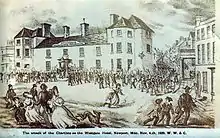
The Westgate Hotel, Commercial Street, Newport, Wales is a hotel building dating from the 19th century. On 4 November 1839 the hotel saw the major scenes of the Newport Rising, when 3,000 Chartists, some of them armed, led by John Frost marched on Newport to attempt to secure the release of five of their number who were being held under arrest at the hotel. In the fighting between about 60 soldiers of the 45th Regiment of Foot and police on one side, and a larger number of Chartists on the other, 10-22 Chartists were killed and more than 50 wounded. The hotel is a Grade II listed building.[1]
History
After the demolition of Newport's original West city gate, the site was reclaimed and a hotel constructed in 1779 on the site of a previous 15th-century house.
The Westgate Hotel was the location of the last large-scale armed rebellion against authority in Great Britain. On 4 November 1839, local politician and activist John Frost led a protest march of 3,000 Chartists, some of them armed, into the centre of Newport. Here he discovered that several Chartists had been arrested and were being held in the Westgate Hotel by police, who were reinforced by soldiers of the 45th Regiment of Foot. Firing began (it is unclear who fired first),[2][3] and in the fighting 10-22 people were killed and more than 50 others wounded.[4] As many as 80 shots were fired into the hotel during the rising.[3] Small holes in the pillars at the entrance to the hotel are assumed, by some, to be bullet holes from the insurrection, although this has not been evidenced.[5] The hotel was substantially rebuilt in 1884 but the original pillars were retained,[6] and the present structure built in French Renaissance style. Designed by local architect E. A. Lansdowne, it incorporated six shops at ground floor level to increase the site's rental income, and placed a new five-storey hotel above, with twice the floor size of the hotel it replaced,[7] which included an ornate ballroom.[8] Built by local builder John Linton, it was leased from its opening in 1886 to Samuel Dean of the Castle Hotel for twenty one years.[9]
In 2009 the building was placed on the Buildings at Risk Register as it had been substantially unoccupied for many years and the condition of its interior was beginning to cause concern. The main staircase and richly decorated public rooms are amongst the best surviving examples in the UK of their period.[10] In 2012 Newport Unlimited announced an initiative to bring the hotel back into use.[11] In May 2017 the property was offered for auction with a guide price of between £1.5M and £1.75M. The building was purchased in October 2017 by Rugby Property Assets Limited of Warwickshire.[12] By 2024, little progress had been made, the building remained subject to vandalism and decay, and the council was considering enforcement action.[13]
Chartist legacy
In 1991 three statues, titled "Union, Prudence, Energy" by sculptor Christopher Kelly, commemorating the 1839 Chartist uprising were installed on Commercial Street in front of the hotel.[4] The hotel also featured in the 1978 Chartist Mural which was demolished during the 2013 development of Friars Walk in Newport city centre.
The story of the rebellion was reflected in the Manic Street Preachers' 2014 song "The View from Stow Hill".[14][15]
In July 2019, Our Chartist Heritage announced they would re-open part of the Westgate Buildings for a temporary display. The charity worked with the consortium who own the building, and local Newport graphic artist Josh Cranton, to bring the building up to a viable state for public access, ahead of the anniversary of the Chartist Rising. The interior was repainted and a free display was organised to commemorate the events of the rising.[16]
Gallery
 Westgate Hotel interior shown during the 2019 partial opening
 The attack of the Chartists on the Westgate Hotel, 4 November 1839
 Union, Prudence, Energy, sculpture outside The Westgate Hotel commemorating the Chartist Movement and 1839 Newport Rising
References
- ↑ Cadw. "Westgate Hotel (Grade II) (3015)". National Historic Assets of Wales. Retrieved 2 April 2020.
- ↑ Andrews, Chris (2002). Britain, 1750-1900 Industry, Trade and Politics. Nelson Thornes. p. 38. ISBN 9780748766741. Retrieved 15 September 2022.
- 1 2 Jones, David (1999). The last rising : the Newport Chartist insurrection of 1839. Cardiff: University of Wales Press. p. 151. ISBN 070831452X. Retrieved 15 September 2022.
- 1 2 John Frost: Leader of the Chartist Rebellion, BBC Wales southeast, last update August 2009. Retrieved 2011-10-30.
- ↑ Westgate Hotel pillars
- ↑ "Westgate Hotel, Newport (21116)". Coflein. RCAHMW. Retrieved 29 September 2021.
- ↑ "The New Westgate Hotel Newport Mon". The Building News. 9 April 1886. Retrieved 3 February 2011.
- ↑ "The Ball Room, Westgate Hotel Newport Mon". The Building News. 23 April 1886. Retrieved 3 February 2011.
- ↑ "1886- Westgate Hotel, Newport, Wales". The Building News/Archiseek. 9 April 1886. Retrieved 9 July 2014.
- ↑ Register of Buildings at Risk (PDF) (Report). Newport City Council. June 2009. p. 54. Archived (PDF) from the original on 2007-10-30. Retrieved 3 February 2011.
- ↑ Westgate Hotel investigation
- ↑ "Newport's Westgate Hotel sold". South Wales Argus. Retrieved 2019-07-15.
- ↑ Thomas, Nicholas; Pigott, Paul (11 January 2024). "Westgate: Decay threatens historic Chartist hotel". South Wales Argus. Retrieved 12 January 2024.
- ↑ Notes from the Band
- ↑ "Newport rebellion, 1839 - the battle for the Westgate Hotel". Chartist Ancestors. Retrieved 2010-09-30.
- ↑ "Hotel at the centre of Chartist uprising to open its doors for first time in more than a decade for graphic novel launch". South Wales Argus. Retrieved 2019-07-15.
51°35′15″N 2°59′48″W / 51.5876°N 2.9966°W
