| Woodville Park Adelaide, South Australia | |||||||||||||||
|---|---|---|---|---|---|---|---|---|---|---|---|---|---|---|---|
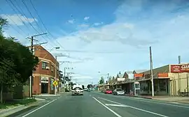
 Looking south on David Terrace. Woodville Park is on the right. | |||||||||||||||
 Woodville Park | |||||||||||||||
| Coordinates | 34°53′S 138°33′E / 34.883°S 138.550°E | ||||||||||||||
| Population | 1,852 (SAL 2021)[1] | ||||||||||||||
| Postcode(s) | 5011 | ||||||||||||||
| Location | 8 km (5 mi) from Adelaide | ||||||||||||||
| LGA(s) | City of Charles Sturt | ||||||||||||||
| State electorate(s) | Cheltenham | ||||||||||||||
| Federal division(s) | Hindmarsh | ||||||||||||||
| |||||||||||||||
Woodville Park is a suburb in the northwestern suburbs of Adelaide, South Australia, around 8 km from the city centre. Woodville Park is bordered to the north by Torrens Road, to the east by Kilkenny Road and David Terrace, to the south by Port Road and to the west by Park Street. It is crossed by the Outer Harbor railway line (southeast to northwest) and is served by the Woodville Park railway station at the northwest end and by Kilkenny railway station on the other side of David Terrace.[2]
References
- ↑ Australian Bureau of Statistics (28 June 2022). "Woodville Park (suburb and locality)". Australian Census 2021 QuickStats. Retrieved 28 June 2022.
- ↑ Google (23 December 2019). "Woodville Park, South Australia" (Map). Google Maps. Google. Retrieved 23 December 2019.
This article is issued from Wikipedia. The text is licensed under Creative Commons - Attribution - Sharealike. Additional terms may apply for the media files.