| Yendon Victoria | |
|---|---|
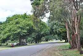
 A tree-lined street in Yendon | |
 Yendon | |
| Coordinates | 37°38′S 143°58′E / 37.633°S 143.967°E |
| Population | 307 (2016 census)[1] |
| Postcode(s) | 3352 |
| Location | |
| LGA(s) | Shire of Moorabool |
| State electorate(s) | Eureka |
| Federal division(s) | Ballarat |
Yendon is a small town in Victoria, Australia. The town is located in the Shire of Moorabool, 108 kilometres (67 mi) west of the state capital, Melbourne and approximately 13 kilometres (8.1 mi) south east of Ballarat. The town was originally called Buninyong East, but was changed in 1879 to Yendon, believed to be an Indigenous Australian word meaning "waterhole".[2]
At the 2016 census, Yendon had a population of 307.[1]
History
The Geelong-Ballarat railway line passed through Yendon, and for a while in the early 1860s it was the terminus of the line. The station was originally called Buninyong, but was changed to Yendon in 1876.[3] A substantial two-storey bluestone station building was opened in 1862. It was demolished in 1969,[2] and the stone was reused to construct garden retaining walls at the Ballarat Institute of Advanced Education, now Federation University.[4]
Yendon's first school, the Common School, opened in 1864, and became Yendon State School in 1879. It closed at the end of 1993.[5][6]
References
- 1 2 Australian Bureau of Statistics (27 June 2017). "Yendon". 2016 Census QuickStats. Retrieved 22 July 2017.
- 1 2 "Yendon". Victorian Places. Retrieved 24 March 2020.
- ↑ "Yendon Township Information Display". Goldfields Guide. Retrieved 24 March 2020.
- ↑ "Photograph - black and white - Yendon Railway Station, 1968". Victorian Collection. Museums Victoria. Retrieved 24 March 2020.
- ↑ Public Record Office Archive, [www.archivalaccessvictoria.com/Downloads/PROV_SCHOOL_LIST.xlsx], accessed 28 November 2016
- ↑ "Plaque, bronze, school". Victorian Collection. Museums Victoria. Retrieved 24 March 2020.
External links