Zardab District | |
|---|---|
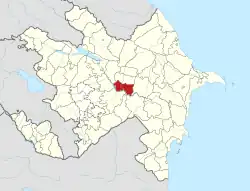
 Map of Azerbaijan showing Zardab District | |
| Country | |
| Region | Central Aran |
| Established | 5 February 1935 |
| Capital | Zardab |
| Settlements[1] | 42 |
| Government | |
| • Governor | Mardan Jamalov |
| Area | |
| • Total | 860 km2 (330 sq mi) |
| Population | |
| • Total | 59,300 |
| • Density | 69/km2 (180/sq mi) |
| Time zone | UTC+4 (AZT) |
| Postal code | 6300 |
| Website | zerdab-ih |
Zardab District (Azerbaijani: Zərdab rayonu) is one of the 66 districts of Azerbaijan. It is located in the centre of the country and belongs to the Central Aran Economic Region. The district borders the districts of Agdash, Ujar, Kurdamir, Imishli, Beylagan, Aghjabadi, and Barda. Its capital and largest city is Zardab. As of 2020, the district had a population of 59,300.[2]
Overview
The regional name Zardab is mentioned in historical publication dating back to the 16th century. As a raion, Zardab was established on February 5, 1935. Located in central Azerbaijan, the raion is 231 km to the west of the capital Baku. It is a part of the larger Arran economic region which also includes Agjabadi, Agdash, Beylagan, Barda, Bilasuvar, Goychay, Hajigabul, Imishli, Kurdamir, Neftchala, Saatli, Sabirabad, Salyan, Ujar raions. The raion lies in a lowland area, in some areas below sea level. The area is 860 km3. Zardab constitutes about 1% of the country and 4% of the Arran economic area.
Weather
The winters in Zardab are mild while the summers are hot with dry subtropic conditions. The temperature reaches 41-44 °C in the summer and +3 °C in the winter. Annual rainfall is 335 mm.
Population
According to the State Statistics Committee, as of 2018, the population of city recorded 58,200 persons, which increased by 11,600 persons (about 19.9 percent) from 46,600 persons in 2000.[3] 29,500 of total population are men, 29,300 are women.[4] More than 26,2 percent of the population (about 15,300 persons) consists of young people and teenagers aged 14–29.[5]
| Region | 2000 | 2001 | 2002 | 2003 | 2004 | 2005 | 2006 | 2007 | 2008 | 2009 | 2010 | 2011 | 2012 | 2013 | 2014 | 2015 | 2016 | 2017 | 2018 | 2019 | 2020 | 2021 |
|---|---|---|---|---|---|---|---|---|---|---|---|---|---|---|---|---|---|---|---|---|---|---|
| Zardab region | 46,6 | 47,3 | 47,8 | 48,4 | 49,0 | 49,7 | 50,5 | 51,3 | 51,9 | 52,6 | 53,3 | 54,0 | 54,8 | 55,4 | 55,8 | 56,5 | 57,1 | 57,7 | 58,2 | 58,8 | 59,3 | 59,7 |
| urban population | 10,8 | 10,9 | 10,9 | 10,9 | 10,9 | 11,0 | 11,0 | 11,0 | 11,0 | 11,0 | 11,2 | 11,3 | 11,4 | 11,5 | 11,6 | 11,6 | 11,7 | 11,8 | 11,9 | 11,9 | 12,0 | 12,0 |
| rural population | 35,8 | 36,4 | 36,9 | 37,5 | 38,1 | 38,7 | 39,5 | 40,3 | 40,9 | 41,6 | 42,1 | 42,7 | 43,4 | 43,9 | 44,2 | 44,9 | 45,4 | 45,9 | 46,3 | 46,9 | 47,3 | 47,7 |
| Ethnic groups | 27 January-3 February 1999 Census [6] | 13-22 April 2009 Census.[7] | ||
|---|---|---|---|---|
| Number | % | Number | % | |
| Total | 46 091 | 100.00 | 52 870 | 100.00 |
| Azerbaijanis | 46 009 | 99.82 | 52 846 | 99.95 |
| Russians | 50 | 0.11 | 19 | 0.04 |
| Tatars | 10 | 0.02 | 1 | 0.00 |
| Ukrainians | 10 | 0.02 | 0 | 0 |
| Turks | 7 | 0.01 | 0 | 0.00 |
| Lezgins | 3 | 0.01 | 1 | 0.00 |
| Avars | 1 | 0.00 | 0.00 | 0.00 |
| Others | 1 | 0.00 | 3 | 0.01 |
Etymology
Zardab is a Persian word (زردآب Zardab) meaning Yellow Water. There are several interpretations of the translation. Some interpret Yellow Water as "dirty water" referring to the dirty debris left after historic floods of the Kura River which goes through the Zardab raion. These floods do not take place any more since the construction of Mingachevir reservoir which prevented the Kura river from overflowing. Another version states the term "yellow" refers to the golden colour. That is, after the floods, the overflown river used to deliver the water necessary for arrogation, therefore making it as precious as gold. And finally, the third version states the reference is made to the second interpretation of the word "Zard" which also means "eatable bird" which in turn refers to the Zərd-əncirquşu birds which are in Zardab's habitat.
Notable natives
- Hasan bey Zardabi, Azerbaijani publicist
References
- ↑ "İnzibati-ərazi vahidləri" (PDF). preslib.az. Retrieved 28 February 2021.
- 1 2 "Population of Azerbaijan". stat.gov.az. State Statistics Committee. Retrieved 22 February 2021.
- 1 2 "Political division, population size and structure: Population by towns and regions of the Republic of Azerbaijan". The State Statistical Committee of the Republic of Azerbaijan. Retrieved 2018-12-18.
- ↑ "Political division, population size and structure: Population by sex, towns and regions, urban settlements of the Republic of Azerbaijan at the beginning of the 2018". The State Statistical Committee of the Republic of Azerbaijan. Retrieved 2018-12-18.
- ↑ "Political division, population size and structure: Population at age 14-29 by towns and regions of the Republic of Azerbaijan at the beginning of the 2018". The State Statistical Committee of the Republic of Azerbaijan. Retrieved 2018-12-18.
- ↑ "Ethnic composition of Azerbaijan 1999". pop-stat.mashke.org. Retrieved 2018-10-12.
- ↑ "Ethnic composition of Azerbaijan 2009". pop-stat.mashke.org. Retrieved 2018-10-12.
External links
40°13′06″N 47°42′30″E / 40.21833°N 47.70833°E