Zimatlán de Alvarez | |
|---|---|
Municipality and town | |
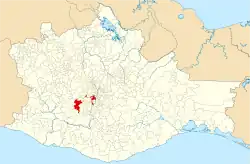
 Location of the municipality in Oaxaca | |
 Zimatlán de Alvarez Location in Mexico | |
| Coordinates: 16°52′N 96°47′W / 16.867°N 96.783°W | |
| Country | |
| State | Oaxaca |
| Area | |
| • Total | 255.16 km2 (98.52 sq mi) |
| Population (2005) | |
| • Total | 18,370 |
| Time zone | UTC-6 (Central Standard Time) |
| • Summer (DST) | UTC-5 (Central Daylight Time) |
Zimatlán de Alvarez is a town and municipality in Oaxaca in south-western Mexico. The municipality covers an area of 255.16 km2. It is part of the Zimatlán District in the west of the Valles Centrales Region, and consists of four separate exclaves.
As of 2005, the municipality had a total population of 18,370.[1]
References
- ↑ "-". Enciclopedia de los Municipios de México. Instituto Nacional para el Federalismo y el Desarrollo Municipal. Retrieved June 12, 2009.
External links
- Santos in Oaxaca's Ancient Churches: San Lorenzo Zimatlán - Art-historical study of artworks in the church, with photographs.
This article is issued from Wikipedia. The text is licensed under Creative Commons - Attribution - Sharealike. Additional terms may apply for the media files.