乌什地区
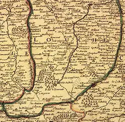
乌什地区(法語:,法语发音:[pe.i duʃ])是法国诺曼底的一个传统地区,涵盖了奥恩省东北部和厄尔省西南部,以里勒河于博蒙勒罗热之上游的河谷为中心,北以沙朗托訥河为界,东以伊通河为界。乌什地区西至欧日地区、法莱斯原野与阿朗松原野,南接佩尔什地区与蒂姆赖地区,东临圣安德烈原野,北至略万地区与勒讷堡原野。乌什地区人口最多的城市是莱格勒。
| 乌什地区 Pays d'Ouche | |
|---|---|
 乌什地区地图,1716年 | |
 乌什地区 乌什地区在法国的位置 | |
| 坐标:48°50′N 0°50′E | |
| 国家 | |
| 大区 | |
| 省 | |
| 主要城镇 | 莱格勒 布勒特伊 乌什地区孔什 吕格勒 |
名胜古迹
参考书目
- Stéphane Gomant, La Société rurale dans le Pays d'Ouche à la fin du XVIIIe siècle, Mutations et permanences des structures socioéconomiques dans le canton de la Ferté-Fresnel, 1770-1830, sous la direction de Jean-Marc Moriceau, Université de Caen Basse-Normandie.
参考文献
外部链接
This article is issued from Wikipedia. The text is licensed under Creative Commons - Attribution - Sharealike. Additional terms may apply for the media files.


