克拉克默斯河
克拉克默斯河(英語:)是美国西北俄勒冈州威拉米特河的一条支流,长约83-英里(134-),流域面积面积约为940平方英里(2,435平方)。克拉克默斯河主要流经区域是其上游的森林和崎岖山地,下游的城市农业和地区仅占三分之一。克拉克默斯河起源于馬里昂縣东部,塞勒姆的东偏东南方向约55英里(89),源头在喀斯喀特山脉胡德山国家森林,海拔4,909英尺(1,496)。从东南方向进入波特兰,在俄勒冈城附近汇入威拉米特河。
| 克拉克默斯河 Clackamas River | |
[[File: Clackamas99Ebridge.jpg|300px|none|位于俄勒冈城的克拉克默斯河大桥 {{|}}]] 位于俄勒冈城的克拉克默斯河大桥 | |
| 名称起源:原住民克拉克默斯人 | |
| 国家 | |
|---|---|
| 省/州/邦 | |
| 县 | 馬里昂縣和克拉克默斯縣 |
| 源头 | Olallie Butte附近 |
| - 位置 | 俄勒冈州馬里昂縣喀斯喀特山脉 |
| - 海拔 | 4,909 ft(1,496 m)[1] |
| 河口 | 威拉米特河 |
| - 位置 | 俄勒冈州克拉克默斯縣俄勒冈城和Gladstone |
| - 海拔 | 10 ft(3 m)[2] |
| 长度 | 83 mi(134 km)[3] |
| 流域面积 | 940 mi²(2,435 km²)[4] |
| 流量 | Estacada西北1.5英里(2.4)处,距离河口23.1英里(37.2) |
| - 平均流量 | 2,750 ft³/s(78 m³/s)[5] |
| - 最大流量 | 86,900 ft³/s(2,461 m³/s) |
| - 最小流量 | 285 ft³/s(8 m³/s) |
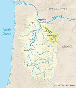
 威拉米特河水系图,高亮为克拉克默斯河流域
| |
| 维基共享资源:Clackamas River | |
参考文献
- Source elevation derived from Google Earth search using GNIS source coordinates.
- Taylor, Barbara. (PDF). Salmon and Steelhead Runs and Related Events of the Clackamas River Basin: A Historical Perspective. Portland General Electric. 1999 [October 11, 2009]. (原始内容存档 (PDF)于2006-03-11).
- . Willamette Riverkeeper. [April 6, 2013]. (原始内容存档于2013-11-10).
- (PDF). United States Geological Survey. [September 11, 2015]. (原始内容存档 (PDF)于2017-02-18). Minimum discharge caused by filling of North Fork Dam forebay on October 5 and 6, 1958.
This article is issued from Wikipedia. The text is licensed under Creative Commons - Attribution - Sharealike. Additional terms may apply for the media files.