北海区
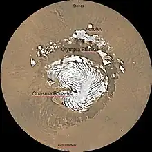
北海区(英語:)是美国地质调查局太空地质学研究计划(Astrogeology Research Program)对火星表面划分的30个区域之一,编号为MC-1。[1]其名称源于火星北极高原的旧名,这是一处被冰帽所覆盖的高原。[2]北海区的范围包括火星表面北纬65°以上的所有区域。
北海区
参考文献
- Davies, M.E.; Batson, R.M.; Wu, S.S.C. “Geodesy and Cartography” in Kieffer, H.H.; Jakosky, B.M.; Snyder, C.W.; Matthews, M.S., Eds. Mars. University of Arizona Press: Tucson, 1992.
- Patrick Moore and Robin Rees, ed. Patrick Moore's Data Book of Astronomy (Cambridge University Press, 2011), p. 130.
| 维基共享资源上的相关多媒体资源:北海区 |
This article is issued from Wikipedia. The text is licensed under Creative Commons - Attribution - Sharealike. Additional terms may apply for the media files.