南马德雷山脉
南马德雷山脉(西班牙語:)是墨西哥南部的山脉,長度為1,000(620英里),其走向為从米却肯州南部向东经格雷罗州,直至瓦哈卡州东部的特万特佩克地峡。南马德雷山脉的最高峰海拔3,720(12,200英尺),位于瓦哈卡州南部。[2]
| 南马德雷山脉 Sierra Madre del Sur | |
|---|---|
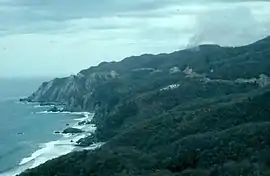
 位於米卻肯州海岸邊的南马德雷山脉 | |
| 最高点 | |
| 山峰 | (Cerro Nube) |
| 海拔 | 3,720(12,200英尺) |
| 17°55′41″N 100°18′0″W | |
| 规模 | |
| 长度 | 1,000(620英里) NW x SE[1] |
| 面积 | 143,447平方(55,385平方英里) |
| 地理 | |
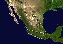
 南马德雷山脉(圖下方)、周圍的一些山脈以及墨西哥高原
| |
| 国家 | 墨西哥 |
| 州 | 米却肯州、格雷羅州、瓦哈卡州 |
参考资料
外部链接
| 维基共享资源中相關的多媒體資源:南马德雷山脉 |
- "Sierra Madre del Sur pine-oak forests". Terrestrial Ecoregions. World Wildlife Fund.
- World Wildlife Fund (编). . WildWorld Ecoregion Profile. National Geographic Society. 2001. (原始内容存档于2010-03-08).
This article is issued from Wikipedia. The text is licensed under Creative Commons - Attribution - Sharealike. Additional terms may apply for the media files.