圣弗朗西斯河
圣弗朗西斯河(英語:)是密西西比河的一条支流,长约426英里(686)[3],位于美国密蘇里州的东南部和阿肯色州东北部。
| St. Francis River | |
| River | |
[[File: St Francis River.jpg|300px|none|位于阿肯色州萊克城的圣弗朗西斯河 {{|}}]] 位于阿肯色州萊克城的圣弗朗西斯河 | |
| 国家 | |
|---|---|
| 省/州/邦 | |
| 地区 | Ozark Plateau、Mississippi Alluvial Plain |
| 区 | St. Francois Mountains、Crowleys Ridge |
| 支流 | |
| - 左侧支流 | 小圣弗朗西斯河、Twelvemile Creek、Blue Spring、Mingo Ditch、Little River |
| - 右侧支流 | Stouts Creek、Marble Creek、Big Creek、Otter Creek、L'Anguille River |
| 城市 | Farmington, Missouri、Fisk, Missouri、Lake City, Arkansas、Marked Tree, Arkansas |
| 源头 | Elephant Rocks State Park |
| - 位置 | 密苏里州Ozark PlateauSt. Francois Mountains艾昂縣 |
| - 海拔 | 1,568 ft(478 m) |
| 河口 | 密西西比河 |
| - 位置 | 阿肯色州Mississippi Alluvial Plain菲利普斯縣海倫娜-西海倫娜附近 |
| - 海拔 | 171 ft(52 m)[1] |
| 长度 | 426 mi(686 km) |
| 流域面积 | 7,550 mi²(19,554 km²)[2] |
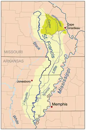
 Map of the St. Francis River watershed. The Castor/Whitewater headwaters (darker shade on the map) were historically part of the St. Francis watershed but are now diverted to the Mississippi.
| |
参考文献
- Senator Pryor Announces Arkansas Projects in Water Resources Development Bill 的存檔,存档日期2009-08-13., Senator Mark Pryor Press Releases
- U.S. Geological Survey. National Hydrography Dataset high-resolution flowline data. The National Map (页面存档备份,存于), accessed March 9, 2011
外部链接
- 哥伦比亚地名词典的北美入口
- 德洛姆 (2004年)。 阿肯色州的Atlas系统和地名索引的。 雅茅斯,缅因州的:德洛姆的。 ISBN 0-89933-345-1的。
- 德洛姆 (2002年)。 密苏里州的Atlas系统和地名索引的。 雅茅斯,缅因州的:德洛姆的。 ISBN 0-89933-353-2的。
- 美國地質調查局地名資訊系統:圣弗朗西斯河
- 密苏里白浪锦标赛
- 地图的前的圣弗朗西斯湖中的东北部阿肯色州
This article is issued from Wikipedia. The text is licensed under Creative Commons - Attribution - Sharealike. Additional terms may apply for the media files.