圣盖博山
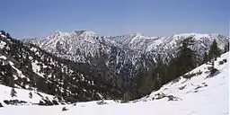
圣盖博山(英語:)是美国加州的一个山脉,位于洛杉矶县北部和圣贝纳迪诺县西部[1],介于洛杉矶盆地和Mojave Desert之间。山脉的最高峰是圣安东尼奥山。威尔逊山是另一个著名的山峰,以威尔逊山天文台著称。
| 圣盖博山 San Gabriel Mountains | |
| Range | |
 | |
| 国家 | 美国 |
|---|---|
| 州 | 加州 |
| 县 | 洛杉矶县、圣贝纳迪诺县 |
| 坐标 | 34.28889°N 117.64672°W |
| 最高點 | Mount San Antonio |
| - 海拔 | 10,068 ft(3,069 m) |
| 长度 | 68.4 mi(110 km) |
| 宽度 | 22.5 mi(36 km) |
| 面积 | 970 mi²(2,512 km²) |
 | |
参考
- . 美国地质局地理名称信息系统. [2009-05-03].
| 维基共享资源上的相关多媒体资源:圣盖博山 |
- Outdoor LA Hiking Trails – Hiking trails in the area with maps and directions to the trailheads.
- Geographic, Biological, and Geological information(页面存档备份,存于)
This article is issued from Wikipedia. The text is licensed under Creative Commons - Attribution - Sharealike. Additional terms may apply for the media files.