地質剖面
地質剖面(英語:) 是一種橫截面示意圖,顯示地層面和構造面與垂直平面相交的地質特徵的圖表,用於說明一個區域的地質結構和地層分佈,包括岩石單元、斷層、地形等。它們通常用於補助俯視的地質圖,闡明該區域的三維結構[1][2].

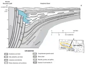
阿納達科盆地 的地質剖面圖。 頂部的字母 A 和 B 對應於較小地圖上標記為 A--B 的線。 在此示例中,垂直比例被誇大
地質剖面可視爲垂直面地質圖,如同地表已被切開,從側面暴露出地表下的地質結構和地層分佈。以各種線條、顏色、圖案和符號用於表示不同的岩石剖面和特徵。如同俯視地質圖一樣,需用比例小圖表示深度或長度的比例。

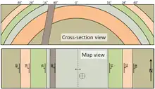
地質剖面顯示一個背斜構造,被一個岩墻穿過,也顯示了走向和傾角資料
地質剖面可包含廣泛的地質資料,這些資料可以包括來自地表、地下和現有地質圖的數據。分析的數據,岩石樣本、結構方位、鑽孔、結構之間的關係、地震勘測等[2]。由於無法直接觀察大部分外來信息,地質剖面存有一些不確定性[3][4]。
參考文獻
- Stieglitz, Ronald D. (1988), "Cross-sections", General Geology, Encyclopedia of Earth Science, Dordrecht: Kluwer Academic Publishers, pp. 100–103, doi:10.1007/0-387-30844-x_21, ISBN 978-0-442-22499-8, retrieved 2021-11-14
- "The geological cross-sections. Institut Cartogràfic i Geològic de Catalunya". www.icgc.cat. Retrieved 2021-11-14
- Randle, Charles H.; Bond, Clare E.; Lark, R. Murray; Monaghan, Alison A. (2018-04-24). "Can uncertainty in geological cross-section interpretations be quantified and predicted?". Geosphere. 14 (3): 1087–1100. Bibcode:2018Geosp..14.1087R. doi:10.1130/GES01510.1. ISSN 1553-040X
- Lark, R. M.; Thorpe, S.; Kessler, H.; Mathers, S. J. (2014-07-17). "Expert modelling of a geological cross-section from boreholes: sources of uncertainty and their quantification" (PDF). Solid Earth Discussions. 6 (2): 1687. Bibcode:2014SolED...6.1687L. doi:10.5194/sed-6-1687-2014.
This article is issued from Wikipedia. The text is licensed under Creative Commons - Attribution - Sharealike. Additional terms may apply for the media files.