大平顶山
气候
以下的气候数据出自位于台地北坡海拔9,800英尺的梅萨湖度假村。
| 梅萨湖度假村,科罗拉多州 | |||||||||||||
|---|---|---|---|---|---|---|---|---|---|---|---|---|---|
| 月份 | 1月 | 2月 | 3月 | 4月 | 5月 | 6月 | 7月 | 8月 | 9月 | 10月 | 11月 | 12月 | 全年 |
| 历史最高温 °F(°C) | 47 (8) |
47 (8) |
56 (13) |
62 (17) |
77 (25) |
78 (26) |
80 (27) |
77 (25) |
75 (24) |
63 (17) |
55 (13) |
48 (9) |
80 (27) |
| 平均高温 °F(°C) | 27.9 (−2.3) |
30.9 (−0.6) |
34.5 (1.4) |
41.0 (5.0) |
52.6 (11.4) |
64.1 (17.8) |
69.2 (20.7) |
66.6 (19.2) |
59.0 (15.0) |
49.0 (9.4) |
34.8 (1.6) |
28.9 (−1.7) |
46.7 (8.2) |
| 平均低温 °F(°C) | 3.4 (−15.9) |
6.1 (−14.4) |
11.3 (−11.5) |
17.4 (−8.1) |
28.1 (−2.2) |
36.9 (2.7) |
43.0 (6.1) |
41.8 (5.4) |
35.5 (1.9) |
26.2 (−3.2) |
14.0 (−10.0) |
4.6 (−15.2) |
22.5 (−5.3) |
| 历史最低温 °F(°C) | −35 (−37) |
−25 (−32) |
−18 (−28) |
−13 (−25) |
10 (−12) |
16 (−9) |
31 (−1) |
28 (−2) |
21 (−6) |
−4 (−20) |
−18 (−28) |
−28 (−33) |
−35 (−37) |
| 平均降水量 (mm) | 2.54 (65) |
2.09 (53) |
2.60 (66) |
2.66 (68) |
1.81 (46) |
1.52 (39) |
2.11 (54) |
1.64 (42) |
1.87 (47) |
2.91 (74) |
2.56 (65) |
2.39 (61) |
26.71 (678) |
| 来源:The Western Regional Climate Center[1] | |||||||||||||
地理

 Cliff edge on western face of the mesa.
 Typical landscape on top of the mesa.
 In the summer, cattle graze atop the mesa.
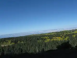
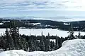 View from Grand Mesa looking south towards Island Lake and the San Juan Mountains.
 Numerous ponds and small lakes dot the top of the Mesa.
 Fall colors atop the mesa.
 Western edge of the mesa.
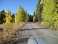 Typical Forest Service road atop the mesa.
 The view towards Grand Junction.
参见
参考
- . Western Regional Climate Center. [March 24, 2013]. (原始内容存档于2015-10-12).
This article is issued from Wikipedia. The text is licensed under Creative Commons - Attribution - Sharealike. Additional terms may apply for the media files.