奥卡尔
奥卡尔[1]是毛里塔尼亚东南部的一个洼地,位于基法与内马之间,塔甘特高原以南。当地的地形主要为沙丘与盐盘,东、北缘有断崖。
| 奥卡尔 عوكر | |
|---|---|
| 自然区域 | |
 阿尤恩阿特鲁斯地区的景象 | |
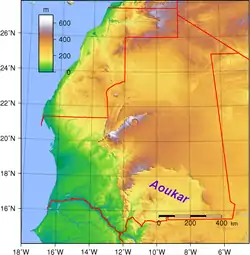 奥卡尔在毛里塔尼亚的位置 | |
| 坐标:18°00′N 9°30′W | |
| 国家 | 毛里塔尼亚 |
| 海拔 | 240 公尺(790 英尺) |
历史
奥卡尔曾是一自流盆地,水边有芦苇生长;湖面积最大时曾到达提希特一带,濒临塔甘特高原,如今已荡然无存。在大约公元前1700年到公元前400年,湖边曾有过文明发展。当地曾有过大约400个村庄。[2][3]
参见
- 毛里塔尼亚地理
参考资料
- Marco Stoppato, Alfredo Bini (2003), Deserts, p. 156
- . [2020-03-17]. (原始内容存档于2016-03-04).
- G. Marcus and B. de Valicourt (2000). Mauritanie, p. 10
- Richard Trillo, The Rough Guide to West Africa
外部链接
This article is issued from Wikipedia. The text is licensed under Creative Commons - Attribution - Sharealike. Additional terms may apply for the media files.