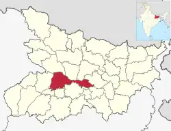
巴特那縣
巴特那縣是印度的一個縣,位於該國東北部,由比哈爾邦負責管轄,面積3,202平方公里,每年平均降雨量1,130毫米,2011年人口5,772,804,人口密度每平方公里1,803人。
| Patna district | |
|---|---|
| 县 | |
 在比哈尔邦的位置 | |
| 坐标:25°25′N 85°10′E | |
| 国家 | |
| 邦 | 比哈尔邦 |
| 专区 | Patna division |
| Headquarters | Patna |
| 政府 | |
| • Lok Sabha constituencies | 1. Patna Sahib, 2. Pataliputra, 3. Munger (shared with Munger district) |
| • Vidhan Sabha constituencies | 14 |
| 面积 | |
| • Total | 3,202 平方公里(1,236 平方英里) |
| 人口(2011) | |
| • Total | 5,838,465人 |
| • 密度 | 1,823人/平方公里(4,723人/平方英里) |
| • 市区 | 2,514,590 (43.7 per cent) (2,011) |
| Demographics | |
| • Literacy | 73.68 per cent[1] |
| • Sex ratio | 897 |
| 时区 | IST(UTC+05:30) |
| 主要高速公路 | NH 30,NH 83 |
| 網站 | http://patna.bih.nic.in |
This article is issued from Wikipedia. The text is licensed under Creative Commons - Attribution - Sharealike. Additional terms may apply for the media files.