布里恩茨红峰
布里恩茨红峰(德語:,意即为“布里恩茨的红色山峰”)是瑞士的山峰,位於該國中北部,橫跨盧塞恩州、上瓦爾登州和伯恩州,屬於埃默河谷山的一部分,海拔高度2,350米,山體由石灰岩組成。
| Brienzer Rothorn | |
|---|---|
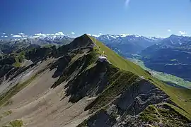 从西侧看去 | |
| 最高点 | |
| 海拔 | 2,350(7,710英尺) |
| 地形突起度 | 1,342(4,403英尺) [1] |
| 地形孤立度 | 9.7(6.0英里) [2] |
| 46°47′13″N 8°02′49″E | |
| 命名 | |
| 譯名 | 布里恩茨的红色山峰 |
| 地理 | |
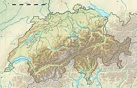 Brienzer Rothorn 在瑞士的位置 | |
| 国家 | 瑞士 |
| 州 | 卢塞恩州, 上瓦爾登州 and 伯恩州 |
| 山脈 | 埃默河谷山 |
| 地形圖 | Swiss Federal Office of Topography swisstopo |
| 攀山 | |
| 最简路线 | 自布里恩茨乘坐登山火车,自Sörenberg乘坐缆车 |
图片
 Steam train (Brienzer Rothorn Bahn) on the Planalp near Mittler Stafel
 Approaching the summit near Ober Stafel
 View of Lake Brienz and Interlaken in the background
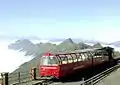 The summit station over the clouds ("sea of fog") during a day in August
參考資料
- Retrieved from the Swisstopo topographic maps. The key col is the Brünig Pass (1,008 m).
- Retrieved from Google Earth. The nearest point of higher elevation is north of the Gärstenhoren (Schwarzhorn massif).
- (地图). Swiss Confederation. [2014-10-21]. (原始内容存档于2016-04-05).
- Brienzer Rothorn on Hikr (页面存档备份,存于)
This article is issued from Wikipedia. The text is licensed under Creative Commons - Attribution - Sharealike. Additional terms may apply for the media files.