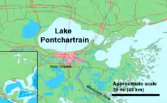
庞恰特雷恩湖
庞恰特雷恩湖(法語:,/ˈpɒntʃətreɪn/;法語:,法语发音:[lak pɔ̃ʃaʁtʁɛ̃] (ⓘ))是美国密西西比河河口湾北岸的一个潟湖,面积1630平方公里,是仅次于大盐湖的美国第二大咸水湖。全湖属路易斯安那州管辖,南岸为都市新奥尔良。
| 庞恰特雷恩湖 | |
|---|---|
 地圖 | |
| 位置 | 路易西安納州 |
| 标 | 30°11′20″N 90°06′05″W |
| 类型 | 河口灣、鹹水湖 |
| 所在国家 | |
| 最大长度 | 40 mi (64 km) |
| 最大宽度 | 24 mi (39 km) |
| 表面积 | 630 sq mi (1630 km²) |
| 平均深度 | 12-14 feet |
| 最大深度 | 65英尺(20) |
| 紐奧良、梅泰里、肯納、曼德維爾、斯萊德爾、麥迪遜維爾 | |
外部链接
| 维基共享资源上的相关多媒体资源:庞恰特雷恩湖 |
- Lake Pontchartrain Basin Foundation (页面存档备份,存于)
- United States Geological Survey Lake Pontchartrain Fact Sheet
- Real-time water data for Lake Pontchartrain (页面存档备份,存于)
- The Lake Pontchartrain Basin Foundation (页面存档备份,存于)
- New Orleans history of the lake
- Lake Pontchartrain Basin Maritime Museum (页面存档备份,存于)
- USGS Environmental Atlas of Lake Pontchartrain (页面存档备份,存于)
- New Orleans District Water Management
- Washington Post article alleging levee faults, 21 Sept 2005 (页面存档备份,存于)
- National Geographic article about the levees, 2 Sept. 2005 (页面存档备份,存于)
- Salon article about disaster predictions, 31 Aug 2005 (页面存档备份,存于)
- U.S. Geological Survey article about the Lake Pontchartrain Basin, 3 Nov 1995
- BBC article about environmental effects on the lake after the flooding of New Orleans, 8 Sept. 2005 (页面存档备份,存于)
This article is issued from Wikipedia. The text is licensed under Creative Commons - Attribution - Sharealike. Additional terms may apply for the media files.