庫奈特拉
庫奈特拉(阿拉伯语:)是敘利亞西南部庫奈特拉省的舊首都。它位在戈蘭高地的山谷,海拔1010公尺(3313英呎)處[1]。庫奈特拉建於奧斯曼帝國時期,為商隊前往大馬士革的中繼站,後來演變成駐軍城鎮,人口2萬人,緊鄰敘利亞和以色列兩國的停火線。它的名稱在阿拉伯文中是「小橋」的意思[2]。
| 庫奈特拉 القنيطرة | |
|---|---|
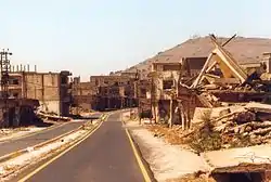 庫奈特拉一景 | |
 庫奈特拉 敘利亞,庫奈特拉。 | |
| 坐标:33°07′32″N 35°49′26″E | |
| 國家 | |
| 省 | 庫奈特拉省 |
| 區 | 庫奈特拉區 |
| 地區 | 戈蘭高地 |
| 建城 | 西元約1000年 |
| 毀城 | 西元1974年 |
| 政府 | |
| • 首長 | Nawaf Abboud al-Fares |
| 海拔[1] | 1,010 公尺(3,313 英尺) |
| 时区 | EET(UTC+2) |
| • 夏时制 | EEST(UTC+3) |
| 電話區號 | 43 |
| 網站 | eQunaytra |
1967年6月10日,第三次中東戰爭的最後一天,庫奈特拉受到以色列占領[3]。敘利亞很快地在1973年的贖罪日戰爭中奪回失城,但以色列隨後發動反攻,再度取得庫奈特拉。直到1974年6月以色列撤軍,庫奈特拉全城幾乎徹底遭到毀滅。它現今被劃屬於敘利亞與以色列實際國界之間,非武裝的聯合國脫離接觸觀察員部隊中,僅居有少數幾戶人家。敘利亞並無計畫重建此城,且強烈反對定居於此區域內。以色列的毀城行為則受到聯合國嚴厲譴責[4],同時以色列也批評敘利亞對庫奈特拉沒有重建的積極作為[5]。
政權狀態
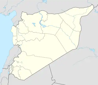
庫奈特拉省座落於敘利亞西南部,地理上囊含整個戈蘭高地。庫奈特拉為其首府,位處戈蘭高地的一部分,為敘利亞所屬[6]。以色列主張其對部分戈蘭高地控有主權,但未獲除美国外其他國家承認。現今戈蘭高地地區普遍被認定是國際法所掌管的佔領區域,但实际上各方均默认了以色列对该地的统治[7]。
參考資料
- Geoffrey William Bromiley. "Golan", in International Standard Bible Encyclopedia: E-J, p. 520. Wm. B. Eerdmans Publishing, 1994. ISBN 0-8028-3782-4
- . [2009-11-19]. (原始内容存档于2008-12-21).
- On 10 June, Israeli authorities utilized a postmark, in Arabic, English and Hebrew, for mail sent from Quneitra. Livni, Israel. Encyclopedia of Israel Stamps. Tel Aviv: Sifriyat Ma'arit, 1969. p.195
- "Report of the Special Committee to Investigate Israeli Practices Affecting the Human Rights of the Population of the Occupied Territories ", UNGA Resolution 3240, 29 November 1974". 3240 report 的存檔,存档日期2011-01-03., unispal.un.org.
- Abraham Rabinovich. The Yom Kippur War, 492. Knopf Publishing Group, 2005. ISBN 0-8052-1124-1
- "Qunaytirah, Al-." Encyclopædia Britannica. 1993
- "Golan Heights" A Dictionary of Contemporary World History. Jan Palmowski. Oxford University Press, 2003. Oxford Reference Online. Oxford University Press.
This article is issued from Wikipedia. The text is licensed under Creative Commons - Attribution - Sharealike. Additional terms may apply for the media files.